IMAGES TAKEN NEAR TO
Marion Road, BRISTOL, BS15 3LE
Introduction
This page details the photographs taken nearby to Marion Road, BS15 3LE by members of the Geograph project.
The Geograph project started in 2005 with the aim of publishing, organising and preserving representative images for every square kilometre of Great Britain, Ireland and the Isle of Man.

There are currently over 7.5m images from over14,400 individuals and you can help contribute to the project by visiting https://www.geograph.org.uk
Image Map (Loading...)


Getting Data...Please wait
Leaflet Map data © OpenStreetMap
Images are licensed for reuse under creativecommons.org/licenses/by-sa/2.0
Notes
- Clicking on the map will re-center to the selected point.
- The higher the marker number, the further away the image location is from the centre of the postcode.
Image Listing (24 Images Found)
Images are licensed for reuse under creativecommons.org/licenses/by-sa/2.0
Image
Details
Distance
1
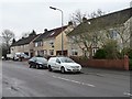
Two pairs of semis on Memorial Road
Once they would have all looked the same.
Image: © Christine Johnstone
Taken: 23 Mar 2013
0.08 miles
2
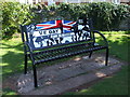
V.E. Day commemorative seat
A striking and beautifully designed park bench in the Recreation Ground marks the anniversary of the end of the war in Europe. It was donated by Hanham Abbots Parish Council for the people of Hanham to mark 75 years after the outbreak of peace.
Image: © Neil Owen
Taken: 30 Jul 2020
0.10 miles
3
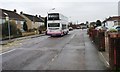
No. 44 bus on Memorial Road
The cyclist is at the 61 metre spot height.
Image: © Christine Johnstone
Taken: 23 Mar 2013
0.11 miles
4
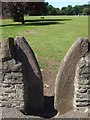
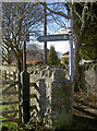
A stile to enter Hanham Recreation Ground
The rustic character of the area remains in some places.
Image: © Neil Owen
Taken: 30 Jul 2020
0.14 miles
5
No Motorcycles or guns!
Another of the notices that seem to abound in the Hencliff Wood area.
Image: © Neil Owen
Taken: 20 Feb 2018
0.14 miles
6
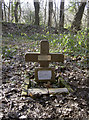
A small cross for a life lost
This simple cross is a poignant reminder of one of the losses incurred during WWII. Deep in the heart of Hencliff Wood, this is the site where an airman lost his life after bailing out of his aircraft.
Wellington Mk X, LN 293, was part of 12 Operational Training Unit, RCAF, based at Chipping Warden near Banbury. It was involved in a deception sortie over Normandy as a distraction for the main bomber raid elsewhere on the night of 25/6 August, 1944. On board were pilot W.O. J.R. Harvey RNZAF, Navigator Sgt. D.M. Paterson RCAF, Wireless Operator Sgt. W.E. Hankin RAFVR, Air Gunners Sgts. A. Blewett RAFVR and D.D. Evans RAFVR. The bomb aimer was a 28-year-old Canadian, Sgt. Frank Samuel Martin (1398507), and it is this site that commemorates him.
Taking off at 20:10, the aircraft was returning from Normandy. It is believed they lost their way and were off the expected course, possibly using the River Avon for reference. At some point they ran into trouble. Reports are not clear - some mention being caught in searchlights and blinding the pilot or receiving 'friendly' fire, despite dropping two yellow flares recognisable to home forces. The end result was that the aircraft went into an uncontrollable dive. Harvey ordered the crew to bail out and Martin did so, along with Hankin. Both seem to have had their parachutes fouled, probably by wrapping around the tail, and they fell to their deaths. The tumbling aircraft came down near Uplands, close to Keynsham and a few miles further along, at 01:46. All the remaining crew perished.
Local information recounts that Martin's body, without parachute, was found by a nine-year-old boy, and it was he who ensured the spot was not left to neglect. Many years later it was given a small cross and plaque.
Pilot Harvey is buried in Carlisle (Dalston Road) cemetery; Paterson in Kingston-upon-Thames cemetery, and Martin was interred in Denham, Buckinghamshire. The main crash site was excavated in the 1980s.
Image: © Neil Owen
Taken: 20 Feb 2018
0.14 miles
7
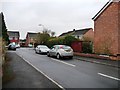
Heading Close
On the south side of Samuel White Road.
Image: © Christine Johnstone
Taken: 23 Mar 2013
0.16 miles
8
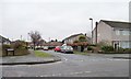
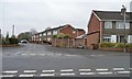
Heath Road
Looking westwards from the junction with Memorial Road.
Image: © Christine Johnstone
Taken: 23 Mar 2013
0.16 miles
9
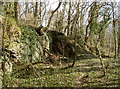
A short cliff face
Some quarrying is a common feature of this stretch of the River Avon.
Image: © Neil Owen
Taken: 20 Feb 2018
0.16 miles
10
The Barton
On the north side of Samuel White Road.
Image: © Christine Johnstone
Taken: 23 Mar 2013
0.17 miles