IMAGES TAKEN NEAR TO
Martins Road, BRISTOL, BS15 3EP
Introduction
This page details the photographs taken nearby to Martins Road, BS15 3EP by members of the Geograph project.
The Geograph project started in 2005 with the aim of publishing, organising and preserving representative images for every square kilometre of Great Britain, Ireland and the Isle of Man.

There are currently over 7.5m images from over14,400 individuals and you can help contribute to the project by visiting https://www.geograph.org.uk
Image Map
Images are licensed for reuse under creativecommons.org/licenses/by-sa/2.0
Notes
- Clicking on the map will re-center to the selected point.
- The higher the marker number, the further away the image location is from the centre of the postcode.
Image Listing (35 Images Found)
Images are licensed for reuse under creativecommons.org/licenses/by-sa/2.0
Image
Details
Distance
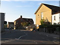
2
Hanham High Street
With a good mixture of small businesses.
Image: © Mike Faherty
Taken: 19 Jul 2011
0.16 miles
3
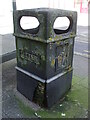
Hard life on Hanham High Street
A commonplace rubbish bin on Hanham High Street: despite being situated by a busy main road and attracting many customers, there are several lichen colonies. Not bad, considering the peeling synthetic covering and the rotting chipboard base underneath.
Image: © Neil Owen
Taken: 23 Feb 2021
0.17 miles
4
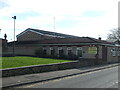
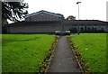
Hanham Community Centre
The centre has a long history, beginning with a small group of First World War veterans who wanted to provide some local amenity for all. Land was donated and various groups gathered to raise sufficient funds for a building. After WWII some wooden huts were obtained and Hanham Folk Centre came into being in 1949. By the early 1960s the stable balance sheets helped offers of more grants. Mr. B. Woodward drew up the architectural plans for new brick buildings as well as improved sports grounds and facilities. The present building was officially opened on 16th June 1964.
Image: © Neil Owen
Taken: 23 Feb 2021
0.17 miles
5
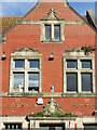
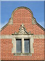
Growing on The Jolly Sailor
Part of the brick frontage of the pub, with some carved masonry and opportunist plants.
Image: © Neil Owen
Taken: 23 Feb 2021
0.18 miles
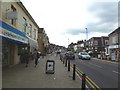
6
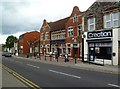
Hanham, The Jolly Sailor
Newly opened Wetherspoons pub on High Street; bar to right, drinking and eating areas left and back, patio. Five cask ales on offer at my visit.
Image: © Mike Faherty
Taken: 19 Jul 2011
0.18 miles
7
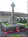
Hanham War Memorial
This stone Celtic cross is the memorial to the men who gave their lives in both World Wars. It was dedicated on 24 February, 1924, and used to stand at the junction of Whittucks Road and Hanham High Street. Owever, increasing traffic prompted a repositioning here in front of the Folk Centre in 1957.
Image: © Neil Owen
Taken: 23 Feb 2021
0.18 miles
8
War memorial garden in Hanham
The frontage for the community centre.
Image: © Bill Boaden
Taken: 28 Sep 2017
0.18 miles
9
Details of The Jolly Sailor
Part of the pub in Hanham.
Image: © Neil Owen
Taken: 23 Feb 2021
0.18 miles
10
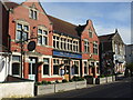
The Jolly Sailor, Hanham High Street
Despite being a long way from water, the pub's current fabric dates from the late ninenteenth century. However, the pub has a much longer history and may be several hundred years old. It actually stands on a Roman road that used to lead to the River Avon - hence its name.
In the 1700s, this pub has the haunt of the notorious Cock Road Gang, who terrorised the locals and the authorities. The ringleader, one George Caine, was transported to Australia in 1812; he became the landlord of The Jolly Sailor in Parammatta, New South Wales.
Image: © Neil Owen
Taken: 23 Feb 2021
0.18 miles