IMAGES TAKEN NEAR TO
High Street, BRISTOL, BS15 3ED
Introduction
This page details the photographs taken nearby to High Street, BS15 3ED by members of the Geograph project.
The Geograph project started in 2005 with the aim of publishing, organising and preserving representative images for every square kilometre of Great Britain, Ireland and the Isle of Man.

There are currently over 7.5m images from over14,400 individuals and you can help contribute to the project by visiting https://www.geograph.org.uk
Image Map
Images are licensed for reuse under creativecommons.org/licenses/by-sa/2.0
Notes
- Clicking on the map will re-center to the selected point.
- The higher the marker number, the further away the image location is from the centre of the postcode.
Image Listing (58 Images Found)
Images are licensed for reuse under creativecommons.org/licenses/by-sa/2.0
Image
Details
Distance
1
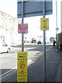
The Hands message in Hanham
Several placards attached to a street sign appear to be courtesy of South Gloucestershire Council.
Image: © Neil Owen
Taken: 23 Feb 2021
0.02 miles
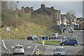
2
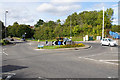
Roundabout at Hanham
On the A431 just west of the centre. To the right will be a new development of assisted housing known as Magpie Court.
Image: © Bill Boaden
Taken: 28 Sep 2017
0.02 miles
3
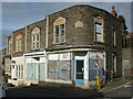
Victoria Buildings, Hanham Street
A former motorcycle workshop lies empty and shuttered up. Known as Victoria Buildings, they are dated 1886.
Image: © Neil Owen
Taken: 23 Feb 2021
0.03 miles
4
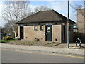
Conveniently on Laburnum Road
A public convenience, open and functioning - quite a rare bird these days. Clearly South Gloucestershire Council feel able to provide them despite the reduction in fundings.
Image: © Neil Owen
Taken: 23 Feb 2021
0.03 miles
5
Kingswood : A431 Roundabout
A roundabout on the A431 on Bryant's Hill and the High Street.
Image: © Lewis Clarke
Taken: 1 Feb 2013
0.03 miles
6
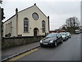
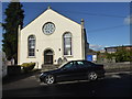
Tabernacle Road's tabernacle
Hanham United Reformed Church.
Image: © Christine Johnstone
Taken: 23 Mar 2013
0.04 miles
7
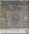
Old Milestone by High Street, Hanham, Bristol
Carved stone post by the A431, in parish of HANHAM ABBOTS (SOUTH GLOUCESTERSHIRE District), High Street, by junction with Tabernacle Road, inset into boundary wall of No. 17a, on East side of road. Erected by the Bristol turnpike trust in the 18th century.
Inscription reads:-
(Bristol)
(8)
(MILES)
(BATH)
9
Milestone Society National ID: GL_BRBA03.
Image: © M Faherty
Taken: 19 Jul 2011
0.04 miles
8
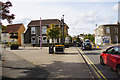
Maypole Square, Hanham
The square has a maypole in the middle. The pub on this side of the square is also called The Maypole.
Image: © Bill Boaden
Taken: 28 Sep 2017
0.04 miles
10
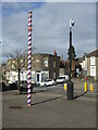
An observant apprentice
The Maypole in Hanham has a new kid on the square. Will it grow up to wear the ribbons as proudly?
Image: © Neil Owen
Taken: 23 Feb 2021
0.05 miles