IMAGES TAKEN NEAR TO
Headington Close, BRISTOL, BS15 3BF
Introduction
This page details the photographs taken nearby to Headington Close, BS15 3BF by members of the Geograph project.
The Geograph project started in 2005 with the aim of publishing, organising and preserving representative images for every square kilometre of Great Britain, Ireland and the Isle of Man.

There are currently over 7.5m images from over14,400 individuals and you can help contribute to the project by visiting https://www.geograph.org.uk
Image Map
Images are licensed for reuse under creativecommons.org/licenses/by-sa/2.0
Notes
- Clicking on the map will re-center to the selected point.
- The higher the marker number, the further away the image location is from the centre of the postcode.
Image Listing (21 Images Found)
Images are licensed for reuse under creativecommons.org/licenses/by-sa/2.0
Image
Details
Distance
1
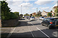
Traffic on Stonehill
The traffic is moving slowly on the A431 approaching Hanham.
Image: © Bill Boaden
Taken: 28 Sep 2017
0.07 miles
2
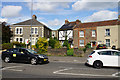
Cottages on Stonehill
Slightly older buildings than a lot of the surrounding suburbia.
Image: © Bill Boaden
Taken: 28 Sep 2017
0.07 miles
3
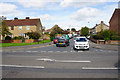
Greenbank Road
A residential road off the A431.
Image: © Bill Boaden
Taken: 28 Sep 2017
0.08 miles
4
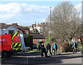
2011 : Dynorod men on an errand of mercy
The houses in the background are on High Street, Hanham.
Image: © Maurice Pullin
Taken: 14 Feb 2011
0.08 miles
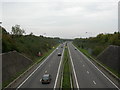
5
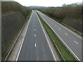
A lockdown scenario
The A4174 would otherwise be continuously occupied but for the Covid situation. At rush hours the traffic would be queueing past here from the Hicks Gate roundabout.
Image: © Neil Owen
Taken: 23 Feb 2021
0.11 miles
6
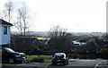
2011 : At the end of Iles Close, Hanham
With a view over the Avon Valley toward Keynsham.
Image: © Maurice Pullin
Taken: 14 Feb 2011
0.12 miles
7
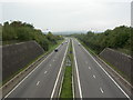
Stone Hill, ring road
A4174, looking towards Hanham Green.
Image: © Mike Faherty
Taken: 8 Oct 2010
0.12 miles
8
Approaching the foot of Hanham hills via footpath PHA22
From the urban fringe off the A431 down a stone lane the green fields of Hanham appear.
Image: © PJK
Taken: 3 May 2017
0.13 miles
9
Stone Hill, ring road
A4174, looking towards Oldland.
Image: © Mike Faherty
Taken: 8 Oct 2010
0.13 miles
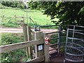
10
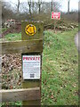
Modern information for walkers
This post on the footpath bears some hi-tech stuff. Given that it expects walkers to have smart phones, it points them at a QR code which should yield some relevant information. Other than that, just stick to the path.
Image: © Neil Owen
Taken: 23 Feb 2021
0.13 miles