IMAGES TAKEN NEAR TO
Jeffries Hill Bottom, BRISTOL, BS15 3BE
Introduction
This page details the photographs taken nearby to Jeffries Hill Bottom, BS15 3BE by members of the Geograph project.
The Geograph project started in 2005 with the aim of publishing, organising and preserving representative images for every square kilometre of Great Britain, Ireland and the Isle of Man.

There are currently over 7.5m images from over14,400 individuals and you can help contribute to the project by visiting https://www.geograph.org.uk
Image Map (Loading...)


Getting Data...Please wait
Leaflet Map data © OpenStreetMap
Images are licensed for reuse under creativecommons.org/licenses/by-sa/2.0
Notes
- Clicking on the map will re-center to the selected point.
- The higher the marker number, the further away the image location is from the centre of the postcode.
Image Listing (43 Images Found)
Images are licensed for reuse under creativecommons.org/licenses/by-sa/2.0
Image
Details
Distance
1
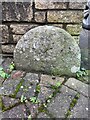
Old Boundary Marker on Jefferies Hill Bottom, Bristol
Municipal Boundary Marker facing east at the end of the garden wall of No 41, on the southwest side of Jefferies Hill Bottom. On the boundary of the City of Bristol and Hanham parish. Formerly Bristol St George and Kingswood parishes.
Milestone Society National ID: GL_BRIHAN03pb
Image: © S Kosciow
Taken: 3 Jan 2022
0.02 miles
2
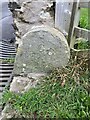
Old Boundary Marker on Jefferies Hill Bottom, Bristol
Municipal Boundary Marker at the southern end of a low stone garden wall on the southeast side of Jefferies Hill Bottom. On the boundary of the City of Bristol and Hanham parish. Formerly Bristol St George and Kingswood parishes. Inscribed C B / 1897.
Milestone Society National ID: GL_BRIHAN02pb
Image: © S Kosciow
Taken: 3 Jan 2022
0.07 miles
3
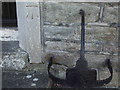
A benchmark and a boot-scraper on Christ Church
The old church has an old welcome as well as a cutmark. See https://www.bench-marks.org.uk/bm130059 for the entry in the Benchmark Database.
Image: © Neil Owen
Taken: 30 Jul 2020
0.13 miles
4
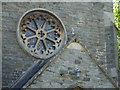
Oriel window on Christ Church
Hanham's large church features a round window above the porch.
Image: © Neil Owen
Taken: 30 Jul 2020
0.14 miles
5
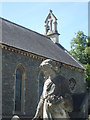
A statue of an angel in Christ Church
Part of the memorials in the graveyard.
Image: © Neil Owen
Taken: 30 Jul 2020
0.14 miles
6
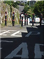
Skittles on Poly Barnes Hill
The road is heavily bisected with a large array of bollards. All it needs is a ball to bowl...
Image: © Neil Owen
Taken: 30 Jul 2020
0.15 miles
7
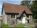
Christ Church Room
The Colin Bailey Room dates from 1896 and is in the grounds of Christ Church.
Image: © Neil Owen
Taken: 30 Jul 2020
0.15 miles
8
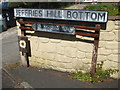
Jeffries Hill Bottom
The valley of Stradbrook leads down the hill to the Conham Vale area and the wildlife reserve.
Image: © Neil Owen
Taken: 30 Jul 2020
0.15 miles
9
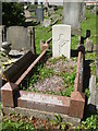
A fallen private
This grave contains the mortal remains of a number of members of the Harrison family. But the one that stands out is the war grave to a Private W.G. Harrison of the Devonshire Regiment. He died in France as the regiment pushed on and is recorded as the 11th November, 1918! Did he really lose his life in the few hours before the armistice or is the date a mere administrative quirk?
Image: © Neil Owen
Taken: 30 Jul 2020
0.15 miles
10
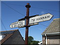
Old signs to the Hundred Steps
The area has been a beauty spot for many years.
Image: © Neil Owen
Taken: 30 Jul 2020
0.15 miles