IMAGES TAKEN NEAR TO
Anglo Office Park, BRISTOL, BS15 1NT
Introduction
This page details the photographs taken nearby to Anglo Office Park, BS15 1NT by members of the Geograph project.
The Geograph project started in 2005 with the aim of publishing, organising and preserving representative images for every square kilometre of Great Britain, Ireland and the Isle of Man.

There are currently over 7.5m images from over14,400 individuals and you can help contribute to the project by visiting https://www.geograph.org.uk
Image Map
Images are licensed for reuse under creativecommons.org/licenses/by-sa/2.0
Notes
- Clicking on the map will re-center to the selected point.
- The higher the marker number, the further away the image location is from the centre of the postcode.
Image Listing (16 Images Found)
Images are licensed for reuse under creativecommons.org/licenses/by-sa/2.0
Image
Details
Distance
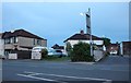
2

Speedwell Methodist Church, Speedwell Road
Services every Sunday.
Image: © Christine Johnstone
Taken: 23 Mar 2013
0.15 miles
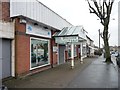
3

Parade of shops, Sunny Bank, Speedwell
Built in 1929, half empty in 2013.
Image: © Christine Johnstone
Taken: 23 Mar 2013
0.16 miles
4
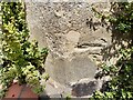
Ordnance Survey Cut Mark
A very damaged OS cut mark. Only the cut line remains and that in poor codition. It can be found on No180 Charlton Road. It marked a point 92.205m above mean sea level.
Image: © Adrian Dust
Taken: 1 Aug 2022
0.18 miles
5
India Brasserie, Speedwell Road
On the south side of the road.
Image: © Christine Johnstone
Taken: 23 Mar 2013
0.18 miles
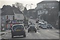
6
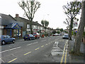
On Speedwell Road, Two Mile Hill, looking west
On Speedwell Road just by its junction with Charlton Road, looking west towards the roundabout-junction
with Whiteway Road. Speedwell Methodist Church is hidden beyond the houses on the left.
Image: © Colin S Pearson
Taken: 23 Oct 2005
0.18 miles
7
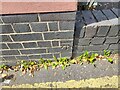
Ordnance Survey Cut Mark
This OS cut mark can be found on the brick building south side of Speedwell Road. It marks a point 88.163m above mean sea level.
Image: © Adrian Dust
Taken: 1 Aug 2022
0.19 miles
8
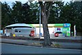
Car Wash on Speedwell Road, Two Mile Hill
Image: © David Howard
Taken: 1 Jun 2019
0.20 miles
9
Bristol : Lodge Causeway B4048
Heading towards the junction with Tricket Avenue on Lodge Causeway.
Image: © Lewis Clarke
Taken: 1 Feb 2013
0.20 miles
10
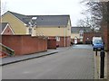
Homes in Coombe Brook Close
A back garden development on the west side of Charlton Road.
Image: © Christine Johnstone
Taken: 23 Mar 2013
0.21 miles