IMAGES TAKEN NEAR TO
Soundwell Road, BRISTOL, BS15 1JW
Introduction
This page details the photographs taken nearby to Soundwell Road, BS15 1JW by members of the Geograph project.
The Geograph project started in 2005 with the aim of publishing, organising and preserving representative images for every square kilometre of Great Britain, Ireland and the Isle of Man.

There are currently over 7.5m images from over14,400 individuals and you can help contribute to the project by visiting https://www.geograph.org.uk
Image Map
Images are licensed for reuse under creativecommons.org/licenses/by-sa/2.0
Notes
- Clicking on the map will re-center to the selected point.
- The higher the marker number, the further away the image location is from the centre of the postcode.
Image Listing (23 Images Found)
Images are licensed for reuse under creativecommons.org/licenses/by-sa/2.0
Image
Details
Distance
3
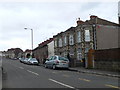
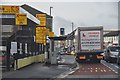
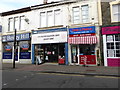
Bristol : Soundwell Road
Soundwell Road heading through the suburbs of Bristol.
Image: © Lewis Clarke
Taken: 1 Feb 2013
0.12 miles
4
Kingswood Methodist Church
Formerly the Zion (Free Methodist) Chapel.
Image: © Neil Owen
Taken: 29 May 2024
0.13 miles
5
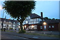
Kingswood : Two Mile Hill Road
Xpress valet centre on the left as we travelled behind a training vehicle.
Image: © Lewis Clarke
Taken: 1 Feb 2013
0.15 miles
6
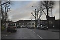
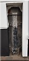
Telephone box on Two Mile Hill Road
Although there are other boxes along such a busy and lengthy stretch of town, this one seems to be trying to camouflage itself among lots of other urban ephemera. See Image] for a wider view of the old factory.
Image: © Neil Owen
Taken: 29 May 2024
0.16 miles
7
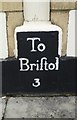
Old Milestone by the A420, Two Mile Hill Road, Bristol
Metal plate attached to brick wall by the A420, in parish of Bristol (City of Bristol District), Two Mile Hill Road, junction with Regent Street, Kingswood (by Estate Agent and Solicitors) No. 379, set low in building wall by pavement, on North side of road. Bristol incised iron plate, erected by the Bristol turnpike trust in the 18th century.
Inscription reads:-
To
Briſtol
3
South Gloucestershire HER listed as part of Nos. 377 and 379 Two Mile Hill Road Kingswood.
HER number: 13161 https://www.heritagegateway.org.uk/Gateway/Results_Single.aspx?uid=13161&resourceID=111
Milestone Society National ID: GL_BRCP03
Image: © M Faherty
Taken: 19 Jul 2011
0.16 miles
8
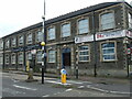
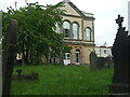
Century's Club
The club (and a few other groups) occupy a former boot and shoe factory. Kingswood was the third largest producing area for the industry in the nineteenth century. See Image] for a closer look at the phone box.
Image: © Neil Owen
Taken: 29 May 2024
0.16 miles
10
Old Boundary Marker
Turnpike Parish Boundary Marker on the north side of the A420 Regent Street. KINGSWOOD parish. ST GEO PH on the left face, BITTON PH on the right face, BRISTOL TURNPIKE TRUST vertically on the front between the two with 1823 above that. Grade II Listed https://historicengland.org.uk/listing/the-list/list-entry/1116168.
Milestone Society National ID: GL_BRCP03pb
Image: © D Dickson
Taken: 23 Mar 2019
0.18 miles