IMAGES TAKEN NEAR TO
Monks Avenue, BRISTOL, BS15 1DJ
Introduction
This page details the photographs taken nearby to Monks Avenue, BS15 1DJ by members of the Geograph project.
The Geograph project started in 2005 with the aim of publishing, organising and preserving representative images for every square kilometre of Great Britain, Ireland and the Isle of Man.

There are currently over 7.5m images from over14,400 individuals and you can help contribute to the project by visiting https://www.geograph.org.uk
Image Map (Loading...)


Getting Data...Please wait
Leaflet Map data © OpenStreetMap
Images are licensed for reuse under creativecommons.org/licenses/by-sa/2.0
Notes
- Clicking on the map will re-center to the selected point.
- The higher the marker number, the further away the image location is from the centre of the postcode.
Image Listing (18 Images Found)
Images are licensed for reuse under creativecommons.org/licenses/by-sa/2.0
Image
Details
Distance
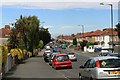
1
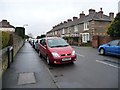
Terraced housing in Glenburn Road
On the west side of Charlton Road.
Image: © Christine Johnstone
Taken: 23 Mar 2013
0.07 miles
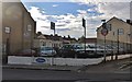
3
Charlton Road at the junction of Two Mile Hill
Image: © David Howard
Taken: 1 Jun 2019
0.09 miles
4
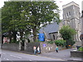
Church of St Michael the Archangel, Two Mile Hill
Image: © William Avery
Taken: 18 Sep 2006
0.10 miles
5
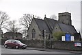
Kingswood : St Michael the Archangel Two Mile Hill
A church on the junction between Kingsway and Two Mile Hill Road.
Image: © Lewis Clarke
Taken: 1 Feb 2013
0.10 miles
6
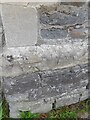
Ordnance Survey Cut Mark
This OS cut mark can be found on west face of St Michael's Church. It marks a point 98.280m above mean sea level.
Image: © Adrian Dust
Taken: 1 Aug 2022
0.10 miles
7
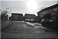
Kingswood : Two Mile Court
Two Mile Court off of Two Mile Hill Road in Kingswood.
Image: © Lewis Clarke
Taken: 1 Feb 2013
0.11 miles
8
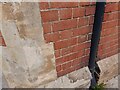
Ordnance Survey Cut Mark
This OS cut mark can be found on The Rose & Crown PH. It marks a point 93.348m above mean sea level.
Image: © Adrian Dust
Taken: 1 Aug 2022
0.13 miles
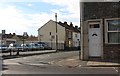
9
2011 : New Queen Street, Two Mile Hill, Bristol
Looking north, heading toward Chester Park.
Image: © Maurice Pullin
Taken: 19 Aug 2011
0.15 miles
10
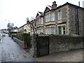
Houses on the west side of Charlton Road
Stone-built semis, then a detached house, then a rendered block of four.
Image: © Christine Johnstone
Taken: 23 Mar 2013
0.17 miles