IMAGES TAKEN NEAR TO
Queen Square, BRISTOL, BS1 4LH
Introduction
This page details the photographs taken nearby to Queen Square, BS1 4LH by members of the Geograph project.
The Geograph project started in 2005 with the aim of publishing, organising and preserving representative images for every square kilometre of Great Britain, Ireland and the Isle of Man.

There are currently over 7.5m images from over14,400 individuals and you can help contribute to the project by visiting https://www.geograph.org.uk
Image Map
Images are licensed for reuse under creativecommons.org/licenses/by-sa/2.0
Notes
- Clicking on the map will re-center to the selected point.
- The higher the marker number, the further away the image location is from the centre of the postcode.
Image Listing (2220 Images Found)
Images are licensed for reuse under creativecommons.org/licenses/by-sa/2.0
Image
Details
Distance
1
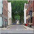
Bristol: Middle Avenue and Queen Square
Looking towards the equestrian statue of King William III in the centre of the square from the bus stop outside the Bristol Hotel on Prince Street.
Image: © John Sutton
Taken: 11 Jun 2017
0.01 miles
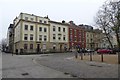
2

Buildings on the west side of Queen Square
Buildings on the west side of Queen Square, with the car park in Prince Street visible through a gap between the buildings.
Image: © Philip Halling
Taken: 28 Feb 2018
0.01 miles
3
Metcalfes Solicitors
Looking towards Metcalfes Solicitors on the western side of Queen Square.
Image: © DS Pugh
Taken: 12 Mar 2014
0.01 miles
4
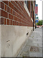
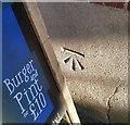
Benchmark on Prince Street
Facing onto Prince Street at the junction with Middle Avenue is a cut benchmark. See http://www.bench-marks.org.uk/bm33800 for the Benchmark Database.
Image: © Neil Owen
Taken: 26 Jul 2011
0.02 miles
5
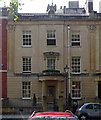
Phoenix House, Queen Square, Bristol
Ashlar facade framed by pilasters with anthemion capitals (as in his terrace on the north side Image]), with a central semi-circular Greek Doric porch and a phoenix surveying it all. Built by Henry Rumley for himself, 1834. Grade II listed.
Queen Square is the best surviving Georgian ensemble in the city centre, and one of the largest Georgian squares in the country. Being laid out from 1699 (and largely complete by 1727) it was the first formal square outside London. The leases stipulated building heights but not much else so there is in general a lack of uniformity.
Now offices.
Image: © Stephen Richards
Taken: 21 May 2012
0.02 miles
6
Ordnance Survey Cut Mark
This OS cut mark can be found on the east side of Prince Street. It marks a point 10.311m above mean sea level.
Image: © Adrian Dust
Taken: 19 Jan 2020
0.02 miles
7
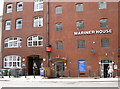
Mariner House and the Y.H.A.
Some of the large and imposing old warehouses, standing right beside what was the heart of the city's port. Naturally, with the closure of these docks other uses have been found for these sturdy buildings.
Image: © Neil Owen
Taken: 18 Jul 2013
0.03 miles
8
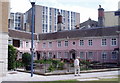
Merchant Venturers' Almshouses, Bristol
Homes for retired mariners since the 17th century. The plaque on the wall is a poem:
"Freed from all storms the tempest and the rage
Of billows, here we spend our age.
Our weather beaten vessels here repair
And from the Merchants' kind and generous care
Find harbour here; no more we put to sea
Until we launch into Eternity.
And lest our Widows whom we leave behind
Should want relief, they too a shelter find.
Thus all our anxious cares and sorrows cease
Whilst our kind Guardians turn our toils to ease.
May they be with an endless Sabbath blest
Who have afforded unto us this rest."
Image: © Eirian Evans
Taken: 24 Jun 2006
0.03 miles
10
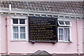
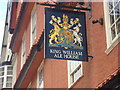
Plaque on the Merchant Venturers' Almshouses
The Society Of Merchant Venturers Almshouses Charity spends about £80,000 a year running accommodation for old mariners and clergymen. This plaque is on the wall of the almshouses on King Street in Bristol. Image
Image: © Eirian Evans
Taken: 6 Aug 2004
0.03 miles