IMAGES TAKEN NEAR TO
The Drive, BRISTOL, BS14 9JB
Introduction
This page details the photographs taken nearby to The Drive, BS14 9JB by members of the Geograph project.
The Geograph project started in 2005 with the aim of publishing, organising and preserving representative images for every square kilometre of Great Britain, Ireland and the Isle of Man.

There are currently over 7.5m images from over14,400 individuals and you can help contribute to the project by visiting https://www.geograph.org.uk
Image Map
Images are licensed for reuse under creativecommons.org/licenses/by-sa/2.0
Notes
- Clicking on the map will re-center to the selected point.
- The higher the marker number, the further away the image location is from the centre of the postcode.
Image Listing (44 Images Found)
Images are licensed for reuse under creativecommons.org/licenses/by-sa/2.0
Image
Details
Distance
1
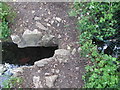
A bridge too short
A stone footbridge is only just holding on.
Image: © Neil Owen
Taken: 29 Apr 2020
0.05 miles
2
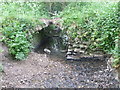
A very short bridge
The stream, a tributary of the Brislington Brook, passes under a small stone footbridge - which is barely a few stones in width these days. See Image] for proof.
Image: © Neil Owen
Taken: 29 Apr 2020
0.05 miles
3
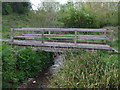
A sturdy crossing
A fine wooden footbridge in the area downstream from the Saltwell Viaduct. Keen observers will have decided that it was not built in 2019, nor built by Lilly.
Image: © Neil Owen
Taken: 29 Apr 2020
0.11 miles
4
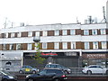
Gilda Parade is gilded with masts
The long rooftop of the shopping rank was too much of an opportunity to miss for the mobile telephone providers.
Image: © Neil Owen
Taken: 7 May 2020
0.12 miles
5
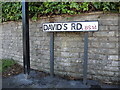
David's Road - with apostrophe
A council sign, with an apostrophe. Compare with the counterpart on the opposite side of the junction - Image
Image: © Neil Owen
Taken: 19 May 2022
0.12 miles
6
A notice of thanks
A popular comment during the Covid-19 pandemic, but this time using vinyl lettering on a utility box.
Image: © Neil Owen
Taken: 7 May 2020
0.12 miles
7
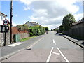
David's Road - take your pick
This is the junction with the Wells Road. On one side is a sign with an apostrophe, on the opposite there is none. See Image] for proof.
Image: © Neil Owen
Taken: 19 May 2022
0.13 miles
8
Trackside lighting
The cycle route has had a clever set of solar-powered lights set into the sides. See Image] for a closer inspection.
Image: © Neil Owen
Taken: 14 Feb 2012
0.13 miles
9
Solar powered light
Along the old railway track, which is now the Whitchurch part of the National Cycle Route 3, are these lights. They are arranged at the track edge alternately. See Image] for a low-down view.
Image: © Neil Owen
Taken: 14 Feb 2012
0.13 miles
10
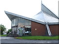
St Bernadette's church, Bristol
A very unusual but distinctive Roman Catholic church on the Wells Road in Whitchurch. Founded in 1968 the roof is described as a double hyperbolic parabaloid and affords the church Grade II listing. The church was designed by James Leask of Kenneth Nealon, Tanner & Partners.
Image: © Neil Owen
Taken: 7 May 2020
0.13 miles