IMAGES TAKEN NEAR TO
Dakota Drive, BRISTOL, BS14 0TE
Introduction
This page details the photographs taken nearby to Dakota Drive, BS14 0TE by members of the Geograph project.
The Geograph project started in 2005 with the aim of publishing, organising and preserving representative images for every square kilometre of Great Britain, Ireland and the Isle of Man.

There are currently over 7.5m images from over14,400 individuals and you can help contribute to the project by visiting https://www.geograph.org.uk
Image Map
Images are licensed for reuse under creativecommons.org/licenses/by-sa/2.0
Notes
- Clicking on the map will re-center to the selected point.
- The higher the marker number, the further away the image location is from the centre of the postcode.
Image Listing (8 Images Found)
Images are licensed for reuse under creativecommons.org/licenses/by-sa/2.0
Image
Details
Distance
1
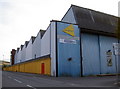
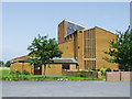
Action Centre
Formerly known as Whitchurch Sports Centre, this was originally Whitchurch Airport. The angled roofing betrays its history as Bristol's primary airport since it was opened in 1930. Many covert flights involved Whitchurch during the Second World War, particularly to neutral Portugal.
Image: © Neil Owen
Taken: 8 Aug 2010
0.15 miles
2
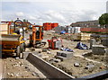
St Augustine's will be reborn
The ill-fated church built in 1972 has been finally demolished before it fell down. The associated vicarage will also follow and a new church built in its place. The money to redevelop this area has been partly raised by the parishioners but the main funding has come from various commercial developers. This will enable them to add eighteen homes with parking spaces to adjoin it. See Image] for a view at the other end of Whitchurch Lane.
Image: © Neil Owen
Taken: 11 Jun 2014
0.18 miles
3
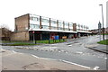
Shops on Belland Drive
This small terrace of shops with apartments above is just off Whitchurch Lane close to its junction with Bamfield.
Image: © Nigel Mykura
Taken: 25 Dec 2021
0.18 miles
4
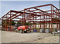
A new place to live and worship
The expansion of Whitchurch in the 1970s brought about the need for a new church for the community. St Augustine's was built in this area, at the foot of the slopes of Dundry ridge. Right from the start there were problems. The original structure had a tall but slender brick belltower, which proved unstable on the damp soils and had to be demolished. Other workmanship defects also surfaced, but little could be done to eliminate them. Lead was stolen from the roof and the resulting water ingress caused more damage. Finally, as a result of the mounting structural problems and a dwindling congregation, it closed in 2007.
Now the site is prime estate for a new start. There will be a new church and also a mixed scheme for eighteen houses. See Image] for another view.
Image: © Neil Owen
Taken: 11 Jun 2014
0.21 miles
5
Whitchurch Park, Bristol, St Augustine's Church
Taken in 2000, the church closed shortly after because of building defects.
Image: © ChurchCrawler
Taken: Unknown
0.23 miles
6
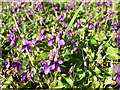
Whitchurch violets
A sunny day has brought out the tender flowers that have remained under cover until now. See Image] for a wider view of the road.
Image: © Neil Owen
Taken: 18 Feb 2014
0.24 miles
7
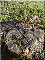
Letting the sun in
A felled tree is now an open area for the violets to show.
Image: © Neil Owen
Taken: 18 Feb 2014
0.24 miles
8
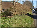
Violets in Whitchurch Lane
It's a pretty uncommon sight to see so many violets in one roadside bank, but this is on the bust Whitchurch Lane. See Image] for a closer look at these Spring blossoms.
Image: © Neil Owen
Taken: 18 Feb 2014
0.24 miles