IMAGES TAKEN NEAR TO
Church Road, BRISTOL, BS14 0PR
Introduction
This page details the photographs taken nearby to Church Road, BS14 0PR by members of the Geograph project.
The Geograph project started in 2005 with the aim of publishing, organising and preserving representative images for every square kilometre of Great Britain, Ireland and the Isle of Man.

There are currently over 7.5m images from over14,400 individuals and you can help contribute to the project by visiting https://www.geograph.org.uk
Image Map
Images are licensed for reuse under creativecommons.org/licenses/by-sa/2.0
Notes
- Clicking on the map will re-center to the selected point.
- The higher the marker number, the further away the image location is from the centre of the postcode.
Image Listing (88 Images Found)
Images are licensed for reuse under creativecommons.org/licenses/by-sa/2.0
Image
Details
Distance
1
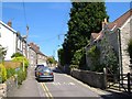
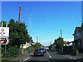
Church Road, Whitchurch
Cottages line the north side of the street. The church is further along off to the right.
Image: © Derek Harper
Taken: 3 Jun 2006
0.02 miles
2
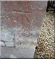
Ordnance Survey Cut Mark
This OS cut mark can be found on the north face of St Nicholas Church. It marks a point 77.779m above mean sea level.
Image: © Adrian Dust
Taken: 15 Sep 2016
0.03 miles
3
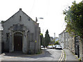
2009 : Old chapel in Church Road, Whitchurch
Denomination unknown. Methodism was strong in this area.
Image: © Maurice Pullin
Taken: 2 May 2009
0.03 miles
5
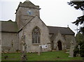
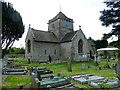
St Nicholas Church, Whitchurch
An ancient church since possibly Saxon times, its history can be seen here http://stnics.net/History/ofStNicholasChurch/tabid/193/Default.aspx. On the buttress to the right of the white banner is a benchmark Image
Image: © Neil Owen
Taken: 18 Feb 2011
0.03 miles
6
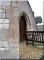
Benchmark on St Nicholas church, Whitchurch
Just near the entrance to this ancient place of worship is a cut mark, last verified in the 1950's.
The church is originally thought to date from Saxon times, dedicated to St Whyte - giving rise to the obvious modern name of the parish, Whitchurch. In later times it was known as St Gregory's, only to become St Nicholas church after the Reformation.
See Image] for a wider view, and http://www.bench-marks.org.uk/bm37083 for the Benchmark Database.
Image: © Neil Owen
Taken: 18 Feb 2011
0.03 miles
7
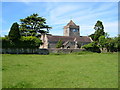
St Nicholas' church, Whitchurch
This scene gives the old village of Whitchurch on the edge of the Bristol suburbs a thoroughly rural look, although much of the surrounding area is composed of housing.
Image: © Derek Harper
Taken: 3 Jun 2006
0.03 miles
8
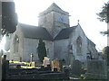
St Nicholas in the frost
The old church of Whitchurch wakes to a frosty, misty morning.
Image: © Neil Owen
Taken: 10 Jan 2021
0.03 miles
10
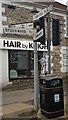
Direction Sign ? Signpost
Located on the northwest side of the junction of the A37 Bristol Road and Church Road in Whitchurch parish. 4 arms and pyramid finial.
Milestone Society National ID: SO_ST6167
Image: © D Dickson
Taken: 22 Jan 2019
0.06 miles