IMAGES TAKEN NEAR TO
Long Acre Road, BRISTOL, BS14 0HJ
Introduction
This page details the photographs taken nearby to Long Acre Road, BS14 0HJ by members of the Geograph project.
The Geograph project started in 2005 with the aim of publishing, organising and preserving representative images for every square kilometre of Great Britain, Ireland and the Isle of Man.

There are currently over 7.5m images from over14,400 individuals and you can help contribute to the project by visiting https://www.geograph.org.uk
Image Map
Images are licensed for reuse under creativecommons.org/licenses/by-sa/2.0
Notes
- Clicking on the map will re-center to the selected point.
- The higher the marker number, the further away the image location is from the centre of the postcode.
Image Listing (7 Images Found)
Images are licensed for reuse under creativecommons.org/licenses/by-sa/2.0
Image
Details
Distance
1
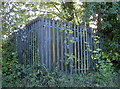
Odd box
A fairly typical sort of sight at the roadside - a utility unit, shielded by a stout fence. No obvious identification, but there are some manhole covers beside it, so perhaps some form of water/sewage plant?
Image: © Neil Owen
Taken: 30 Oct 2017
0.15 miles
3
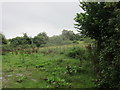
Rough grazing adjacent to East Dundry Road
Image: © Dr Duncan Pepper
Taken: 21 Aug 2013
0.16 miles
4
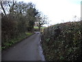
East Dundry Road looking uphill from Whitchurch
Very narrow & twisty and few passing places-not for the slow witted driver.
Image: © Dr Duncan Pepper
Taken: 21 Aug 2013
0.20 miles
5
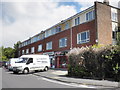
Local parade of shops, East Dundry Lane
Image: © Roger Cornfoot
Taken: 7 Jun 2011
0.23 miles
6
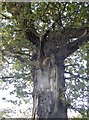
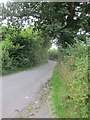
Gnarled oak on East Dundry Road
Standing tall and leafy despite losing some substantial lumber.
Image: © Neil Owen
Taken: 30 Oct 2017
0.23 miles
7
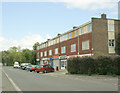
2009 : Row of shops on East Dundry Lane
Not a promising sight unless you want a haircut, but wait till you get to the top of the hill.
Image: © Maurice Pullin
Taken: 26 May 2009
0.24 miles