IMAGES TAKEN NEAR TO
Salmon Mead, BRISTOL, BS14 0FL
Introduction
This page details the photographs taken nearby to Salmon Mead, BS14 0FL by members of the Geograph project.
The Geograph project started in 2005 with the aim of publishing, organising and preserving representative images for every square kilometre of Great Britain, Ireland and the Isle of Man.

There are currently over 7.5m images from over14,400 individuals and you can help contribute to the project by visiting https://www.geograph.org.uk
Image Map
Images are licensed for reuse under creativecommons.org/licenses/by-sa/2.0
Notes
- Clicking on the map will re-center to the selected point.
- The higher the marker number, the further away the image location is from the centre of the postcode.
Image Listing (71 Images Found)
Images are licensed for reuse under creativecommons.org/licenses/by-sa/2.0
Image
Details
Distance
1
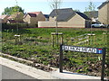
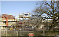
Salmon Mead
The new housing development on the outskirts of Whitchurch has made use of some natural water features. There are no salmon in it, though.
Image: © Neil Owen
Taken: 13 Apr 2020
0.03 miles
2
White Church Court
Just a couple of months after Image, and I imagine weather has hindered progress quite a bit.
Image: © Derek Harper
Taken: 10 Mar 2018
0.07 miles
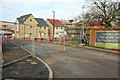
3
White Church Court
A new development of a small housing estate takes shape along Queen Charlton Lane, adjoining that to the north called 'The Bridles'. It seems that two different developers are creating new homes back to back.
Image: © Neil Owen
Taken: 7 Jan 2018
0.08 miles
4
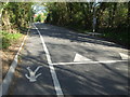
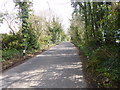
On Queen Charlton Lane
The new housing estate has brought with it some extra road features, including a lane set aside for pedestrians.
Image: © Neil Owen
Taken: 13 Apr 2020
0.08 miles
5
Tree protection zone
The impact and mess of new houses are kept apart from the old tree as construction takes place all around.
Image: © Neil Owen
Taken: 7 Jan 2018
0.09 miles
6
Whitchurch, Queen Charlton Lane
Lane from Bristol Road to Queen Charlton.
Image: © Mike Faherty
Taken: 30 Mar 2014
0.09 miles
7
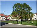
Maes Knoll Drive
The new housing estate that has grown up has respected a large oak tree and made a feature of it. It was the only tree in an ordinary field before the diggers moved in.
Image: © Neil Owen
Taken: 13 Apr 2020
0.10 miles
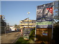
8
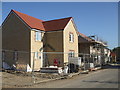
Plot 100 is on the market
Although there is some work still outstanding, this house is being offered for sale. It must be one of the last to be built here.
Image: © Neil Owen
Taken: 13 Apr 2020
0.11 miles
9
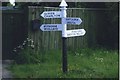
Old Direction Sign - Signpost by Queen Charlton Road, Whitchurch
Pyramid finial - 4 arms; Somerset SCC pyramid by the A37, in parish of Whitchurch (Bath And North East Somerset District), Queen Charlton Road, opposite Sleep Lane.
Surveyed
Milestone Society National ID: SO_ST6167B.
Image: © Milestone Society
Taken: 1 Jan 2013
0.12 miles
10
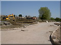
Laying out the roads first
The houses will come later.
Image: © Neil Owen
Taken: 19 Apr 2018
0.12 miles