IMAGES TAKEN NEAR TO
Norton Lane, BRISTOL, BS14 0BU
Introduction
This page details the photographs taken nearby to Norton Lane, BS14 0BU by members of the Geograph project.
The Geograph project started in 2005 with the aim of publishing, organising and preserving representative images for every square kilometre of Great Britain, Ireland and the Isle of Man.

There are currently over 7.5m images from over14,400 individuals and you can help contribute to the project by visiting https://www.geograph.org.uk
Image Map
Images are licensed for reuse under creativecommons.org/licenses/by-sa/2.0
Notes
- Clicking on the map will re-center to the selected point.
- The higher the marker number, the further away the image location is from the centre of the postcode.
Image Listing (8 Images Found)
Images are licensed for reuse under creativecommons.org/licenses/by-sa/2.0
Image
Details
Distance
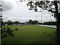
1
Looking down
From the east ramparts of the Iron Age hillfort, Maes Knoll, the rich farmlands of the lower slopes are catching the last of the afternoon sun. Along this line ran the Wansdyke, a Celtic feature that went several miles at least towards the hill fort of Stantonbury Hill, and then on towards Bath.
Image: © Neil Owen
Taken: 1 Feb 2012
0.10 miles
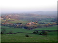
2
No coal on this line
Neither as a fuel for the Bristol and North Somerset Railway locomotives, nor as a product of the collieries of Pensford and Radstock, this is the remnant line of the old tracks leading south from Bristol. It began life after a fairly torrid financial start in 1873. Having suffered from the loss of much of the coal fields around this area and also from the damage of the Great Storm of 1968 that forced the closure of the Pensford viaduct, the line finally closed in 1973. The tracks were ripped up and the land returned to agriculture. The hedge lines stand as a green monument to the old railway.
Image: © Neil Owen
Taken: 20 Jun 2018
0.14 miles
3
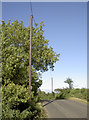
A new set of lines
New poles have recently been installed here: that essential village quality, broadband, is coming soon!
Image: © Neil Owen
Taken: 20 Jun 2018
0.16 miles
4
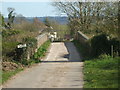
A bridge over a disappeared railway
The old Bristol and North Somerset railway used to run underneath this bridge, but the line closed in 1973.
Image: © Neil Owen
Taken: 4 Apr 2020
0.16 miles
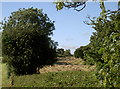
5
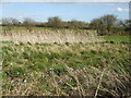
Marshy area near Whitewood Farm
Following the line of the old railway is some obviously wet land.
Image: © Neil Owen
Taken: 4 Apr 2020
0.19 miles
6
Pasture near Blackrock
A miscellany of animals in this field west of the A37. Only the horses get a coat.
Image: © Brian Robert Marshall
Taken: 1 Jul 2007
0.22 miles
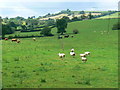
7

2009 : Sheep pasture near New Barn Farm
Cattle are in the next field.
The view is south, looking at hills beyond Stanton Wick.
Image: © Maurice Pullin
Taken: 16 Jun 2009
0.24 miles