IMAGES TAKEN NEAR TO
Pinecroft, BRISTOL, BS14 0AB
Introduction
This page details the photographs taken nearby to Pinecroft, BS14 0AB by members of the Geograph project.
The Geograph project started in 2005 with the aim of publishing, organising and preserving representative images for every square kilometre of Great Britain, Ireland and the Isle of Man.

There are currently over 7.5m images from over14,400 individuals and you can help contribute to the project by visiting https://www.geograph.org.uk
Image Map
Images are licensed for reuse under creativecommons.org/licenses/by-sa/2.0
Notes
- Clicking on the map will re-center to the selected point.
- The higher the marker number, the further away the image location is from the centre of the postcode.
Image Listing (18 Images Found)
Images are licensed for reuse under creativecommons.org/licenses/by-sa/2.0
Image
Details
Distance
1
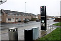
Bus Stop and Houses on Bamfield
This is the Alverstoke bus stop on Bamfield next to the small residential cul de sac known as Alverstoke
Image: © Nigel Mykura
Taken: 25 Dec 2021
0.06 miles
2
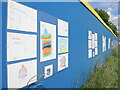
Appealing to future buyers
The new houses going up on Airport Road have long hoardings. In one particular spot, the boards are covered with contributions from local primary schoolchildren. Quite what the developers expect from the coloured in drawings in open to speculation. Maybe they will be customers of the next generations.
Image: © Neil Owen
Taken: 12 May 2022
0.12 miles
3
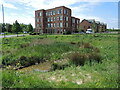
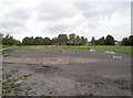
A new pond for the new business park
The Filwood Green Business Park is a pretty recent addition to the area. Previously this was the northern end of Whitchurch Airport, which saw vital service in WWII before being closed in the late 1950s. There is a brook that runs across the Airport Road but this pond is part of the latest landscaping; the buildings occupy the site of one of the hangars.
Image: © Neil Owen
Taken: 12 May 2022
0.12 miles
4
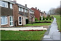
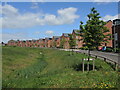
Front of Houses on Swainswick
There is no road in front of these houses whose rear backs on to Swainswick. They face a small green area that leads from Bamfield through to Hengrove Park whcich can be seen in the distance.
Image: © Nigel Mykura
Taken: 25 Dec 2021
0.15 miles
5
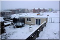
Snow on the Building Site
This large construction site is just north of the A4174 Hengrove Way close to its junction with Creswicke Rd. Taken from one of the houses in Creswicke Rd backing on to the construction site which used to be playing fields.
Image: © Nigel Mykura
Taken: 1 Feb 2019
0.18 miles
6
Manning Road, Knowle
A curve of new housing on the old Whitchurch Airport site.
Image: © Neil Owen
Taken: 12 May 2022
0.20 miles
7
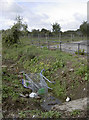
Asda will be one short
A traditional sight: a shopping trolley in a drainage ditch. Back in the 1950s this was part of Whitchurch Airport - one of very few airports to remain open to non-military transport in WWII.
Image: © Neil Owen
Taken: 9 Sep 2017
0.20 miles
8
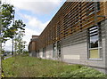
Greenery at the Green
The modern offices and business park looks onto the Airport Road, with a section of the front given over to some suitably wild flowers and shrubs - such is the outlook of modern architectural and environmental thinking. The building itself carries the latest in green energy use and conservation, as seen by the louvred panels and air circulation units that replace conventional air-conditioning systems.
Image: © Neil Owen
Taken: 9 Sep 2017
0.21 miles
9
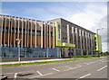
Filwood Green Business Park
Built in 2015, the facility incorporates the latest in green and environmentally-focussed thinking. It has solar panelling, earthen roof sections that grow wildlife-friendly plants, air circulation and heating systems, electric car charging points and has been awarded BREEAM accreditation. Inside, the furniture is mainly recycled from materials once used in the Council chambers and remade by a local charity workshop.
Image: © Neil Owen
Taken: 9 Sep 2017
0.21 miles
10
Bare berms
A small area in the old airport grounds has been given over to the local youths. It is not clear if it will be retained when the area is developed for housing in the near future.
Image: © Neil Owen
Taken: 9 Sep 2017
0.21 miles