IMAGES TAKEN NEAR TO
Bond Street South, BRISTOL, BS1 3PJ
Introduction
This page details the photographs taken nearby to Bond Street South, BS1 3PJ by members of the Geograph project.
The Geograph project started in 2005 with the aim of publishing, organising and preserving representative images for every square kilometre of Great Britain, Ireland and the Isle of Man.

There are currently over 7.5m images from over14,400 individuals and you can help contribute to the project by visiting https://www.geograph.org.uk
Image Map (Loading...)


Getting Data...Please wait
Leaflet Map data © OpenStreetMap
Images are licensed for reuse under creativecommons.org/licenses/by-sa/2.0
Notes
- Clicking on the map will re-center to the selected point.
- The higher the marker number, the further away the image location is from the centre of the postcode.
Image Listing (564 Images Found)
Images are licensed for reuse under creativecommons.org/licenses/by-sa/2.0
Image
Details
Distance
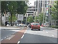
1
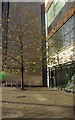
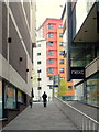
Buildings on Bond Street South, Bristol
The three buildings on the left actually form three-quarters of one building, Phoenix Court, as shown in Image To the right is Market Gate. It's all student accommodation.
Image: © Derek Harper
Taken: 30 Jan 2015
0.02 miles
2
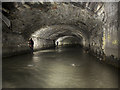
Hidden River Frome
The River Frome disappears underneath Bristol city centre at Broad Weir. Near the junction of Rupert St and Christmas St the majority of the discharge is diverted into Mylnes Culvert to exit at the New Cut while the remainder emerges at the Floating Harbour.
Image: © Noel Jenkins
Taken: 12 Feb 2012
0.03 miles
3
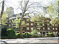
St Matthias House
This twentieth century housing stands on the old Asher Lane and where Rich's Buildings once were. Close by were the burial grounds of the church and part of the land was used as a recreation ground in the late nineteenth century.
Image: © Neil Owen
Taken: 26 Apr 2022
0.03 miles
4
By Cabot Circus
A plane tree and bicycle stands beside Next on Bond Street South.
Image: © Derek Harper
Taken: 29 Nov 2017
0.04 miles
5
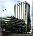
Castlegate Tower
Viewed across Temple Way. An imposing structure which is prominent from around the city.
Image: © Thomas Nugent
Taken: 7 Sep 2010
0.04 miles
7
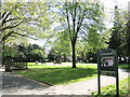
St Matthias Park
There has been a public park in this spot near the church since the old burial grounds were given up to the city around the turn of the 1900s.
Image: © Neil Owen
Taken: 26 Apr 2022
0.04 miles
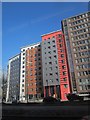
8
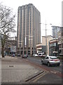
Urban colour
A surprising glimpse of colour at the end of a monochrome pedestrianised street just off Bristol's Cabot Centre.
Image: © Jonathan Billinger
Taken: 2 May 2015
0.05 miles
9
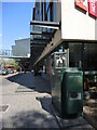
Pollution monitoring on Bond Street South
A green utility box with additional bits topside keeps tabs on the air quality in the middle of town.
Image: © Neil Owen
Taken: 26 Apr 2022
0.05 miles