IMAGES TAKEN NEAR TO
The Horsefair, BRISTOL, BS1 3JP
Introduction
This page details the photographs taken nearby to The Horsefair, BS1 3JP by members of the Geograph project.
The Geograph project started in 2005 with the aim of publishing, organising and preserving representative images for every square kilometre of Great Britain, Ireland and the Isle of Man.

There are currently over 7.5m images from over14,400 individuals and you can help contribute to the project by visiting https://www.geograph.org.uk
Image Map (Loading...)


Getting Data...Please wait
Leaflet Map data © OpenStreetMap
Images are licensed for reuse under creativecommons.org/licenses/by-sa/2.0
Notes
- Clicking on the map will re-center to the selected point.
- The higher the marker number, the further away the image location is from the centre of the postcode.
Image Listing (825 Images Found)
Images are licensed for reuse under creativecommons.org/licenses/by-sa/2.0
Image
Details
Distance
1
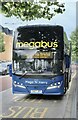
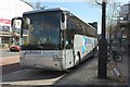
NOT by Royal Appointment!
Intercity bus at its stand in Bond Street
Image: © Anthony O'Neil
Taken: 31 Aug 2021
0.02 miles
2
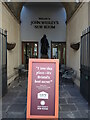
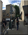
Bristol's best kept secret?
The entrance to the John Wesley Room, a cradle of Methodism. The sign perhaps infers that coffee is the secret, and is endorsed by Michael Eavis - Glastonbury Festival founder, dairy farmer and devout Methodist.
Image: © Neil Owen
Taken: 11 Oct 2022
0.02 miles
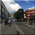
4
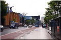
Broadmead ? stop for northbound buses, Bond Street, Bristol
Broadmead is a shopping centre that extends south of here (right). The bust stop is outside Debenhams Bond Street frontage. Bond Street enters the St James' Barton gyratory, left.
Image: © Robin Stott
Taken: 24 Jun 2017
0.02 miles
5
Coach, Bond Street, Bristol
This French Jezequel Tourisme coach is based at Belle Isle en Terre in Brittany.
Image: © Derek Harper
Taken: 20 Apr 2016
0.02 miles
6
Ramped footway between Bond Street and The Horsefair, Bristol
The cul-de-sac to the left off The Horsefair is Barr's Court. The Horsefair runs around the north side of the Broadmead shopping area.
Image: © Robin Stott
Taken: 31 May 2017
0.02 miles
7
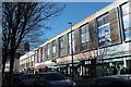
Shops on Horsefair, Bristol
Including two clothes shops, a shoe shop, an entertainment exchange and a newsagent.
Image: © Derek Harper
Taken: 24 Feb 2016
0.03 miles
8
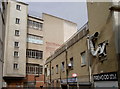
A little strip of green buried in the brick and concrete
The Broadmead area was largely rebuilt after WWII as the prime shopping precinct. High on the top of the various rooflines are small, thin strips where shop-owners can enjoy the sunshine.
Image: © Neil Owen
Taken: 26 Jun 2017
0.03 miles
9
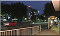
East on The Horsefair, Broadmead, Bristol
The Horsefair runs round the north side of the Broadmead shopping area; buses only, one-way west-to-east.
Image: © Robin Stott
Taken: 31 May 2017
0.03 miles
10
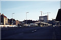
Inner Circuit Rd near Stokes Croft Roundabout, Bristol
This view has drastically changed since this photograph was taken. Not only has the road layout changed but the building seen under construction called Tollgate House has since been demolished.
Image: © Colin Park
Taken: 15 Dec 1974
0.03 miles