IMAGES TAKEN NEAR TO
Queens Road, BRISTOL, BS13 8QE
Introduction
This page details the photographs taken nearby to Queens Road, BS13 8QE by members of the Geograph project.
The Geograph project started in 2005 with the aim of publishing, organising and preserving representative images for every square kilometre of Great Britain, Ireland and the Isle of Man.

There are currently over 7.5m images from over14,400 individuals and you can help contribute to the project by visiting https://www.geograph.org.uk
Image Map (Loading...)


Getting Data...Please wait
Leaflet Map data © OpenStreetMap
Images are licensed for reuse under creativecommons.org/licenses/by-sa/2.0
Notes
- Clicking on the map will re-center to the selected point.
- The higher the marker number, the further away the image location is from the centre of the postcode.
Image Listing (5 Images Found)
Images are licensed for reuse under creativecommons.org/licenses/by-sa/2.0
Image
Details
Distance
1
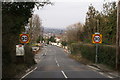
Bristol City Limits by Withywood
Image: © Adrian and Janet Quantock
Taken: 11 Mar 2006
0.11 miles
2
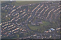
North Somerset : Bristol Suburbs
Flying above North Somerset looking down towards the Bristol suburbs with Four Acres Primary School and the surrounding residential area in view.
Image: © Lewis Clarke
Taken: 27 Aug 2014
0.19 miles
3
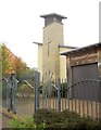
Church, Withywood
An ecumenical church at the Withywood Centre which opened in 2006.
Image: © Derek Harper
Taken: 16 Nov 2013
0.22 miles
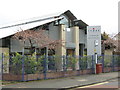
5
The Withywood Centre
"The centre now provides a church, a health centre, community cafe, function halls, internet cafe, youth cafe, play zone, meeting rooms, advice centre and project offices" http://www.bristolpost.co.uk/Vote-community-buildings-RIBA-awards/story-11296771-detail/story.html .
Image: © Derek Harper
Taken: 16 Nov 2013
0.25 miles