IMAGES TAKEN NEAR TO
Queens Road, BRISTOL, BS13 8EZ
Introduction
This page details the photographs taken nearby to Queens Road, BS13 8EZ by members of the Geograph project.
The Geograph project started in 2005 with the aim of publishing, organising and preserving representative images for every square kilometre of Great Britain, Ireland and the Isle of Man.

There are currently over 7.5m images from over14,400 individuals and you can help contribute to the project by visiting https://www.geograph.org.uk
Image Map
Images are licensed for reuse under creativecommons.org/licenses/by-sa/2.0
Notes
- Clicking on the map will re-center to the selected point.
- The higher the marker number, the further away the image location is from the centre of the postcode.
Image Listing (20 Images Found)
Images are licensed for reuse under creativecommons.org/licenses/by-sa/2.0
Image
Details
Distance
1
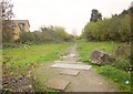
Vacant land, Bishopsworth
Being linear in nature, this look rather like the course of an old railway line, but there was none here. Could it have been intended as a road by planners? On the left is Image
Image: © Derek Harper
Taken: 16 Nov 2013
0.10 miles
2

Waverley Gardens, Bishopsworth
"Waverley Gardens is an extra care housing scheme owned and operated by Brunelcare, which provides housing, care and support for older people ... Opened in September 2009, the scheme consists of 66 apartments" http://www.housinglin.org.uk/Topics/ECHScheme/search/Overview/?cid=8305 .
Image: © Derek Harper
Taken: 16 Nov 2013
0.10 miles
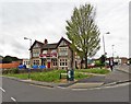
3
Queen's Road, Bishopsworth
Taken from Grange Road, which from the junction ahead with Queen's Road becomes ... Queen's Road! In the background is Dundry Hill.
Image: © Derek Harper
Taken: 16 Nov 2013
0.12 miles
4
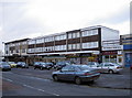
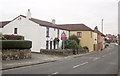
Church Road shops
Parking is a little tight here.
Image: © Neil Owen
Taken: 4 Feb 2013
0.16 miles
5
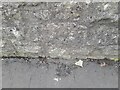
Ordnance Survey Cut Mark
This OS cut mark can be found on the wall east side of Church Road. It marks a point 51.895m above mean sea level.
Image: © Adrian Dust
Taken: 28 Sep 2023
0.16 miles
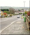
6
Houses on Queen's Road
At the bend is the junction with King George's Road. Just this side of the junction is the pink facade of the Queen's Arms.
Image: © Derek Harper
Taken: 16 Nov 2013
0.16 miles
7
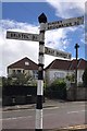
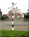
Direction Sign ? Signpost
Located on the south side of the Y junction of Church Road and Grange Road in Bishopsworth, Bristol. 4 arms, 1 missing, and pyramid finial. For an older photo see https://www.geograph.org.uk/photo/6049110.
Milestone Society National ID: SO_ST5768
Image: © S Kosciow
Taken: 26 Apr 2019
0.17 miles
8
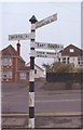
Old Direction Sign - Signpost in Bishopsworth, Bristol parish
Pyramid finial - 4 arms; Somerset SCC pyramid by the UC road, in parish of Bristol (City of Bristol District), Bishopsworth; junction of Church Road with Grange Road.
To be surveyed
Milestone Society National ID: SO_ST5768
Image: © Milestone Society
Taken: Unknown
0.17 miles
9
Signpost, Bishopsworth
An old signpost at the junction of Church Road and Grange Road.
Image: © Derek Harper
Taken: 16 Nov 2013
0.17 miles