IMAGES TAKEN NEAR TO
William Jessop Way, BS13 0FE
Introduction
This page details the photographs taken nearby to William Jessop Way, BS13 0FE by members of the Geograph project.
The Geograph project started in 2005 with the aim of publishing, organising and preserving representative images for every square kilometre of Great Britain, Ireland and the Isle of Man.

There are currently over 7.5m images from over14,400 individuals and you can help contribute to the project by visiting https://www.geograph.org.uk
Image Map (Loading...)


Getting Data...Please wait
Leaflet Map data © OpenStreetMap
Images are licensed for reuse under creativecommons.org/licenses/by-sa/2.0
Notes
- Clicking on the map will re-center to the selected point.
- The higher the marker number, the further away the image location is from the centre of the postcode.
Image Listing (20 Images Found)
Images are licensed for reuse under creativecommons.org/licenses/by-sa/2.0
Image
Details
Distance
1
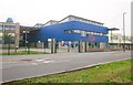
Bridge Learning Campus - Secondary
The new secondary school part of the campus. On the right of the blue building is the Bridge College Centre, part of City of Bristol College.
Image: © Derek Harper
Taken: 16 Nov 2013
0.05 miles
2
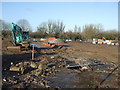
School's out - forever!
The former Helen Bloom Centre is now being cleared for a modern housing development. Along with part of the adjoining business park area, the development is to provide a mix of two and three bed homes of two to four storeys in height.
Image: © Neil Owen
Taken: 29 Jan 2020
0.06 miles
3
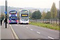
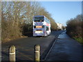
Buses on William Jessop Way
A 76 service passes a 75 heading into Hartcliffe down a road created a few years ago that links two of City of Bristol College's southern campuses, Bridge College Centre (on the left by the buses, and alongside Bridge Secondary) and South Bristol Skills Academy. Both bus services run from Hengrove Depot right across the city to Cribbs Causeway, but by different routes.
Image: © Derek Harper
Taken: 16 Nov 2013
0.06 miles
4
Bridge Learning Campus - Secondary
A view of the eastern past of the building shown in Image
Image: © Derek Harper
Taken: 16 Nov 2013
0.07 miles
5
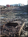
A drain left for the moment
The former Hartcliffe Comprehensive school is now gone, although some of the services remain for the time being. Within a short while the site will be developed for ninety-four houses.
Image: © Neil Owen
Taken: 29 Jan 2020
0.11 miles
6
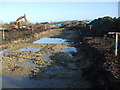
A new road on the old school
The site of Hartcliffe Comprehensive school has been levelled and is about to see a housing development rise.
Image: © Neil Owen
Taken: 29 Jan 2020
0.12 miles
7
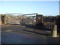
What the pupils wanted
The gates to the former Parkview site and the associated scholarly institutions are firmly shut. Work is now on-going to build a small housing estate. This area was originally open fields but chosen for the creation of new schools in the late 1950s, However, the changing of population and local policies has led to the move to housing.
Image: © Neil Owen
Taken: 29 Jan 2020
0.13 miles
8
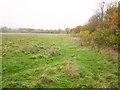
Former playing fields by William Jessop Way
These must have been used as playing fields by Hartcliffe Comprehensive School. They look as if they are awaiting development by City of Bristol College, which has several buildings in the vicinity. On the right is a narrow belt of trees behind which is Parkview Office Campus.
Image: © Derek Harper
Taken: 16 Nov 2013
0.14 miles
9
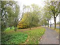
Trees by Hareclive Road
The grassy area is sloping down to the Pigeonhouse Stream.
Image: © Derek Harper
Taken: 16 Nov 2013
0.15 miles
10
The William Jessop Way
A new road which is only open to buses, cycles and taxis. It links the South Bristol Skills Academy and the South Bristol Community Hospital with the communities west of them.
Image: © Neil Owen
Taken: 29 Jan 2020
0.16 miles