IMAGES TAKEN NEAR TO
Bishport Avenue, BRISTOL, BS13 0BW
Introduction
This page details the photographs taken nearby to Bishport Avenue, BS13 0BW by members of the Geograph project.
The Geograph project started in 2005 with the aim of publishing, organising and preserving representative images for every square kilometre of Great Britain, Ireland and the Isle of Man.

There are currently over 7.5m images from over14,400 individuals and you can help contribute to the project by visiting https://www.geograph.org.uk
Image Map (Loading...)


Getting Data...Please wait
Leaflet Map data © OpenStreetMap
Images are licensed for reuse under creativecommons.org/licenses/by-sa/2.0
Notes
- Clicking on the map will re-center to the selected point.
- The higher the marker number, the further away the image location is from the centre of the postcode.
Image Listing (7 Images Found)
Images are licensed for reuse under creativecommons.org/licenses/by-sa/2.0
Image
Details
Distance
1
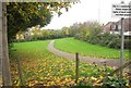
Willmott Park, Hartcliffe
A footpath follows a thread of green space, here leaving Bishport Avenue and heading between houses on Moxham Drive (right) and Borver Grove.
Image: © Derek Harper
Taken: 16 Nov 2013
0.13 miles
2
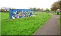
Container, Willmott Park, Hartcliffe
Colourful fishes decorate a container by a playground near Moxham Drive. The semis with all the solar panels are on Kilmersdon Road.
Image: © Derek Harper
Taken: 16 Nov 2013
0.13 miles
3
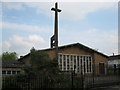
St Andrew, Hartcliffe
Parish Church in Hartcliffe.
Image: © don cload
Taken: 12 Apr 2009
0.17 miles
4
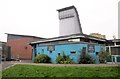
Hareclive Youth Centre
On Moxham Drive, Hartcliffe.
Image: © Derek Harper
Taken: 16 Nov 2013
0.17 miles
5
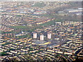
Hartcliffe from the air
A southern suburb of Bristol. The three tower blocks are Hayleigh, Middleford and Millmead Houses, all handy for the adjacent Morrison's.
Image: © M J Richardson
Taken: 23 Dec 2015
0.18 miles
6
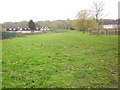
Open space, Hartcliffe
From the point where footpath BCC/306 leaves Bishport Avenue to cross the field and climb Dundry Hill.
Image: © Derek Harper
Taken: 16 Nov 2013
0.19 miles
7
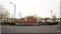
Morrisons, Hartcliffe
With the petrol station in the foreground. This is the junction of Silcox Road with Hareclive Road (foreground).
Image: © Derek Harper
Taken: 16 Nov 2013
0.20 miles