IMAGES TAKEN NEAR TO
Lower Maudlin Street, BRISTOL, BS1 2LY
Introduction
This page details the photographs taken nearby to Lower Maudlin Street, BS1 2LY by members of the Geograph project.
The Geograph project started in 2005 with the aim of publishing, organising and preserving representative images for every square kilometre of Great Britain, Ireland and the Isle of Man.

There are currently over 7.5m images from over14,400 individuals and you can help contribute to the project by visiting https://www.geograph.org.uk
Image Map
Images are licensed for reuse under creativecommons.org/licenses/by-sa/2.0
Notes
- Clicking on the map will re-center to the selected point.
- The higher the marker number, the further away the image location is from the centre of the postcode.
Image Listing (1020 Images Found)
Images are licensed for reuse under creativecommons.org/licenses/by-sa/2.0
Image
Details
Distance
1
Dental Hospital
On Lower Maudlin Street. See also Image
Image: © Thomas Nugent
Taken: 12 Sep 2011
0.02 miles
2
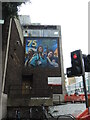
Lower Maudlin Street mural
Appropriate as the area is almost all hospitals.
Image: © Neil Owen
Taken: 10 Sep 2024
0.02 miles
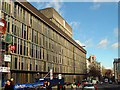
3
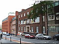
Lower Maudlin Street
Home to the Eye Hospital and the Dental Hospital, with Bristol Royal Infirmary on Marlborough Street in the distance.
Image: © Thomas Nugent
Taken: 12 Sep 2011
0.02 miles
4
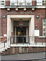
Dental Hospital
With doors open wide on Lower Maudlin Street. See also Image
Image: © Thomas Nugent
Taken: 12 Sep 2011
0.02 miles
5
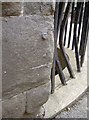
Almost gone
This is all that now remains of a bolt benchmark, located on the corner of the Bristol Royal Infirmary in Upper Maudlin Street, adjoining Lower Maudlin Street. Once (back in the mid nineteenth century) it would have had a full set of arrows and a datum line rather like this one in Portland Square:Image
See http://www.bench-marks.org.uk/bm28904 for more details of the marks in the Benchmark Database.
Image: © Neil Owen
Taken: 23 Nov 2011
0.02 miles
6
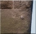
Ordnance Survey 1GL Bolt
This OS Bolt can be found on the west angle of the Royal Infirmary. It marks a point 20.513m above mean sea level.
Image: © Adrian Dust
Taken: 26 Jan 2020
0.03 miles
7
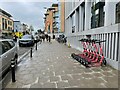
Travel West e-scooter hire
Upper Maudlin Street.
The website states "Our region is the first area in the UK to offer residents both the Voi hop-on hop-off and the long-term rental options.
The trial is led by the West of England Combined Authority in partnership with Bath & North East Somerset Council, Bristol City Council and South Gloucestershire Council.
The West of England is one of only four Future Transport Zones in the country, set up to trial new transport technologies to cut congestion, improve air quality and reduce carbon emissions."
Image: © Fernweh
Taken: 1 Aug 2021
0.03 miles
9
Bristol Royal Infirmary (BRI)
Looking north-east along Marlborough Street with the BRI hospital on the left.
Image: © Linda Bailey
Taken: 6 Mar 2006
0.04 miles
10
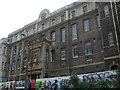
The old part of the BRI
Bristol's Royal Infirmary is an ancient institution that has provided care for many years. However, more modern buildings have been built since and this one is now closed.
Image: © Neil Owen
Taken: 25 Apr 2019
0.04 miles