IMAGES TAKEN NEAR TO
Station Road, BRISTOL, BS11 9TU
Introduction
This page details the photographs taken nearby to Station Road, BS11 9TU by members of the Geograph project.
The Geograph project started in 2005 with the aim of publishing, organising and preserving representative images for every square kilometre of Great Britain, Ireland and the Isle of Man.

There are currently over 7.5m images from over14,400 individuals and you can help contribute to the project by visiting https://www.geograph.org.uk
Image Map
Images are licensed for reuse under creativecommons.org/licenses/by-sa/2.0
Notes
- Clicking on the map will re-center to the selected point.
- The higher the marker number, the further away the image location is from the centre of the postcode.
Image Listing (101 Images Found)
Images are licensed for reuse under creativecommons.org/licenses/by-sa/2.0
Image
Details
Distance
1
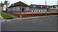
St Bernard's RC Primary School, Shirehampton, Bristol
Viewed across Station Road. The Roman Catholic school is opposite St Bernard's Catholic Church. http://www.geograph.org.uk/photo/3281096
Image: © Jaggery
Taken: 23 Jun 2012
0.01 miles
2
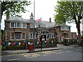
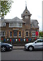
Shirehampton Public Hall, Bristol
Located at 20 Station Road. The main part of the building contains a hall with a stage and balcony seating, which can be booked for shows, parties, other activities and exhibitions for up to 200 people. The right side of the building is occupied by Shirehampton public library, part of Bristol City Council's library service.
The foundation stone for the building was laid October 3rd, 1903. The new building was officially opened (as the Parish Hall and Carnegie Library) on September 29th, 1904. See http://www.geograph.org.uk/photo/3281095 for a view of the clock tower on the right, which is hidden by tree branches in this view.
Image: © Jaggery
Taken: 23 Jun 2012
0.03 miles
3
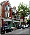
A short row of Station Road shops, Shirehampton, Bristol
In view are The Pet Shop and PJ's Hairdressing & Barber Shop.
Image: © Jaggery
Taken: 23 Jun 2012
0.03 miles
4
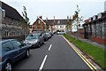
Pembroke Avenue, Shirehampton, Bristol
This is the St Bernard's Church http://www.geograph.org.uk/photo/3281096 part of Pembroke Avenue, the course of which bends to the right ahead.
Image: © Jaggery
Taken: 23 Jun 2012
0.03 miles
5
Clock tower, Shirehampton Library, Bristol
Viewed across Station Road. The library occupies part of the Public Hall. http://www.geograph.org.uk/photo/3281094
Image: © Jaggery
Taken: 23 Jun 2012
0.03 miles
6
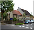
St Bernard's RC church, Shirehampton, Bristol
The Roman Catholic church is located on the corner of Station Road and Pembroke Avenue.
The original church opened for worship here in 1903. It was much smaller than the church seen here, accommodating only 65 worshippers. There were various extensions and alterations during the following decades.
Image: © Jaggery
Taken: 23 Jun 2012
0.04 miles
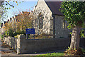
7
St Bernard's Catholic Church, Shirehampton
Image: © Roger Cornfoot
Taken: 9 Dec 2019
0.04 miles
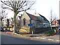
8
St Bernard's Catholic Church, Shirehampton
This church which stands on the corner of Station Road and Pembroke Avenue dates from 1903, although it was extended in the 1920s to serve the rapidly expanding district.
Image: © Stephen McKay
Taken: 10 Nov 2010
0.04 miles
9
Shirehampton Baptist Church, Bristol
The church is at 17 Station Road.
Image: © Jaggery
Taken: 23 Jun 2012
0.04 miles
10
Corner of Station Road and Pembroke Road, Shirehampton, Bristol
Viewed across Station Road. The businesses on the left are Charity Search (dedicated to helping older people in financial need) and Chung's fish & chips and Chinese meals to take away.
Image: © Jaggery
Taken: 23 Jun 2012
0.06 miles