IMAGES TAKEN NEAR TO
Green Lane, BRISTOL, BS11 9JD
Introduction
This page details the photographs taken nearby to Green Lane, BS11 9JD by members of the Geograph project.
The Geograph project started in 2005 with the aim of publishing, organising and preserving representative images for every square kilometre of Great Britain, Ireland and the Isle of Man.

There are currently over 7.5m images from over14,400 individuals and you can help contribute to the project by visiting https://www.geograph.org.uk
Image Map
Images are licensed for reuse under creativecommons.org/licenses/by-sa/2.0
Notes
- Clicking on the map will re-center to the selected point.
- The higher the marker number, the further away the image location is from the centre of the postcode.
Image Listing (144 Images Found)
Images are licensed for reuse under creativecommons.org/licenses/by-sa/2.0
Image
Details
Distance
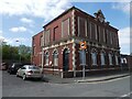
1
Building on the corner of Green Lane and Portview Road
Looks as if it was once a pub.
Image: © Jonathan Thacker
Taken: 15 Sep 2018
0.04 miles
2
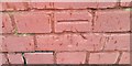
Ordnance Survey Cut Mark
This OS cut mark can be found on No96 Portview Road. It marks a point 7.916m above mean sea level.
Image: © Adrian Dust
Taken: 22 Nov 2016
0.04 miles
3
Napier Road, Avonmouth
Is there any way I can justify adding this to Image? Well, the weight limit sign has been updated. That really is a very narrow end terrace that has been squeezed in. It is divided into two one-bedroom flats.
Image: © Derek Harper
Taken: 19 Oct 2016
0.04 miles
4
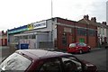
Avonmouth old fire station
Avonmouth old fire station, Green Lane, Avonmouth, Avon, now used as a branch of ATS Euromaster. The original appliance bays have been bricked up, and the main door is in what was the side of the station. It was replaced by Image
Image: © Kevin Hale
Taken: 27 Apr 2008
0.04 miles
5
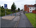
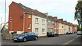
Traffic calming on Portview Road, Avonmouth, Bristol
The houses are in Napier Road. http://www.geograph.org.uk/photo/3299808
The Severn Beach railway line is behind the wall on the left.
Image: © Jaggery
Taken: 23 Jun 2012
0.04 miles
6
Napier Road, Avonmouth, Bristol
Viewed from Portview Road looking towards Avonmouth Road.
Image: © Jaggery
Taken: 23 Jun 2012
0.04 miles
7
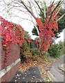
Virginia Creeper, Portview Road, Avonmouth
Parthenocissus quinquefolia, at a bend in the road which forces it to run parallel to the railway line behind the wall.
Image: © Derek Harper
Taken: 19 Oct 2016
0.05 miles
8
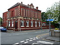
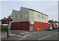
Avonmouth Masonic Hall, Bristol
Viewed from Green Lane. The Portview Road hall is adjacent to Avonmouth Tavern. http://www.geograph.org.uk/photo/3299800
The questions "what is it?" and "when was it built?" are answered by inscriptions on the building:
Masonic Hall and 1904.
To a third question, "why are all the upper floor windows bricked up?", I have no answer.
Image: © Jaggery
Taken: 23 Jun 2012
0.05 miles
10
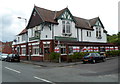
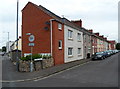
Avonmouth Tavern, Avonmouth, Bristol
The pub is at 95 Portview Road. The rear of the building is at the edge of the Severn Beach railway line.
Image: © Jaggery
Taken: 23 Jun 2012
0.05 miles