IMAGES TAKEN NEAR TO
Avonmouth Road, BRISTOL, BS11 9EG
Introduction
This page details the photographs taken nearby to Avonmouth Road, BS11 9EG by members of the Geograph project.
The Geograph project started in 2005 with the aim of publishing, organising and preserving representative images for every square kilometre of Great Britain, Ireland and the Isle of Man.

There are currently over 7.5m images from over14,400 individuals and you can help contribute to the project by visiting https://www.geograph.org.uk
Image Map
Images are licensed for reuse under creativecommons.org/licenses/by-sa/2.0
Notes
- Clicking on the map will re-center to the selected point.
- The higher the marker number, the further away the image location is from the centre of the postcode.
Image Listing (143 Images Found)
Images are licensed for reuse under creativecommons.org/licenses/by-sa/2.0
Image
Details
Distance
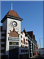
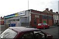
1
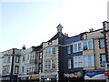
Shop fronts on Avonmouth Road
The area around Avonmouth was opened up in the early twentieth century, with this fine row of shops topped by a few neat details.
Image: © Neil Owen
Taken: 6 Feb 2023
0.00 miles
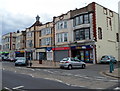
2
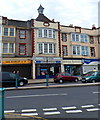
Avonmouth Road shops, Bristol
Viewed from Smyths Close, Avonmouth. From left to right are:
Gym Ratz (fitness and gym equipment).
M&M Kebabs & Pizza.
Parsons Bakery (established 1926).
Vantage Pharmacy (Avonmouth Pharmacy Ltd).
Image: © Jaggery
Taken: 23 Jun 2012
0.01 miles
3
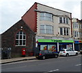
Avonmouth post office, Bristol
The post office is inside the Co-operative Food Store at 193-195 Avonmouth Road.
Image: © Jaggery
Taken: 23 Jun 2012
0.01 miles
4
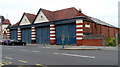
Garage side of the former Avonmouth bus depot, Bristol
Viewed across Avonmouth Road. Now in use as Bob's Gym, the large building was formerly a bus depot. In view are the four former bus garage doors. See http://www.geograph.org.uk/photo/3299419 for a corner view and some notes.
Image: © Jaggery
Taken: 23 Jun 2012
0.02 miles
5
The old bus depot
With more ornate features than would nowadays be made for a mere depot, the building was built to serve the north end of Bristol's public transport service. Its use has since been changed and is now a commercial site, with various tennants over the years.
Image: © Neil Owen
Taken: 6 Feb 2023
0.02 miles
6
Row of shops, Avonmouth Road, Avonmouth, Bristol
Nearest the camera are a William Hill betting office and Captain Cod, fish & chips shop. The green building in the distance is the Co-operative Food Store http://www.geograph.org.uk/photo/3299468 containing Avonmouth's post office.
Image: © Jaggery
Taken: 23 Jun 2012
0.02 miles
7
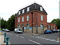
Avonmouth Police Station, Bristol
The imposing building on the corner of Avonmouth Road and Smyths Close is part of Avon and Somerset Constabulary.
Image: © Jaggery
Taken: 23 Jun 2012
0.02 miles
8
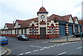
Grade II listed former bus depot, Avonmouth, Bristol
Now in use as Bob's Gym, the building is on the corner of Avonmouth Road and Smyths Close, opposite Avonmouth Police Station. http://www.geograph.org.uk/photo/3299303 An inscription on the wall on the left (Smyths Close) side shows
AD 1915, the year that the building was erected as the Bristol Tramways Company Avonmouth Depot.
The depot offices were along the Smyths Close side. The four bus garage doors are on the right. http://www.geograph.org.uk/photo/3299440
The building later became the Avonmouth Depot for the Bristol Omnibus Company.
Grade II listed in March 1977.
Image: © Jaggery
Taken: 23 Jun 2012
0.02 miles
9
Avonmouth old fire station
Avonmouth old fire station, Green Lane, Avonmouth, Avon, now used as a branch of ATS Euromaster. The original appliance bays have been bricked up, and the main door is in what was the side of the station. It was replaced by Image
Image: © Kevin Hale
Taken: 27 Apr 2008
0.03 miles
10
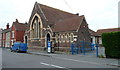
The Old Church, Avonmouth, Bristol
Now in business use, the former church occupies the corner of Collins Street and Avonmouth Road.
Image: © Jaggery
Taken: 23 Jun 2012
0.03 miles