IMAGES TAKEN NEAR TO
Gloucester Road, BRISTOL, BS11 9AQ
Introduction
This page details the photographs taken nearby to Gloucester Road, BS11 9AQ by members of the Geograph project.
The Geograph project started in 2005 with the aim of publishing, organising and preserving representative images for every square kilometre of Great Britain, Ireland and the Isle of Man.

There are currently over 7.5m images from over14,400 individuals and you can help contribute to the project by visiting https://www.geograph.org.uk
Image Map
Images are licensed for reuse under creativecommons.org/licenses/by-sa/2.0
Notes
- Clicking on the map will re-center to the selected point.
- The higher the marker number, the further away the image location is from the centre of the postcode.
Image Listing (140 Images Found)
Images are licensed for reuse under creativecommons.org/licenses/by-sa/2.0
Image
Details
Distance
1
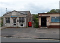
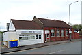
Barclays, Avonmouth
The bank branch is in Gloucester Road.
Image: © Jaggery
Taken: 23 Jun 2012
0.00 miles
2
Gloucester Road, Avonmouth
The terrace https://www.historicengland.org.uk/listing/the-list/list-entry/1202234 shown in Image], with the Royal Hotel http://www.geograph.org.uk/search.php?i=66803290 on the corner. On the right is a building contractor's premises.
Image: © Derek Harper
Taken: 19 Oct 2016
0.01 miles
3
Gloucester Road Avonmouth at level crossing
Image: © Roy Hughes
Taken: 17 Apr 2021
0.02 miles
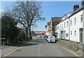
4
Terrace, Gloucester Road, Avonmouth
Listed and described at https://www.historicengland.org.uk/listing/the-list/list-entry/1202234 as a "Parade of shops and an hotel ... c1870s ... An imposing and well-detailed terrace front". There are no longer any shops, but the hotel is still there Image
Image: © Derek Harper
Taken: 19 Oct 2016
0.02 miles
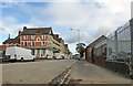
5
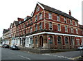
Grade II listed part of Gloucester Road, Avonmouth, Bristol
This whole line of buildings along Gloucester Road, from the corner of Meadow Street near the camera, past the three cars on the left, to the corner of Clayton Street, is Grade II listed. The listing includes the Royal Hotel http://www.geograph.org.uk/photo/3305399 at the left edge of the view.
The buildings, dating from c1870, were Grade II listed in March 1977.
Image: © Jaggery
Taken: 23 Jun 2012
0.02 miles
6
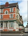
Royal Hotel, Avonmouth
See also http://www.geograph.org.uk/search.php?i=66803290 . Together with the adjoining terrace, it is Listed and described at https://www.historicengland.org.uk/listing/the-list/list-entry/1202234 . "Designed in the late 1870s and opened in 1880/1, the hotel was elaborate by Bristol standards" https://www.historicengland.org.uk/listing/the-list/list-entry/1202234 .
Image: © Derek Harper
Taken: 19 Oct 2016
0.02 miles
7
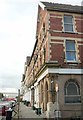
Terrace, Gloucester Road, Avonmouth
Another view of the listed terrace https://www.historicengland.org.uk/listing/the-list/list-entry/1202234 also shown in Image and Image On the right is Meadow Street.
Image: © Derek Harper
Taken: 19 Oct 2016
0.02 miles
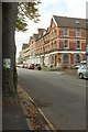
8
Balti Raj, Avonmouth, Bristol
The traditional Indian cuisine restaurant and takeaway at 98 Gloucester Road is near the Clayton Street junction.
Image: © Jaggery
Taken: 23 Jun 2012
0.02 miles
9
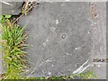
Ordnance Survey Rivet
This OS rivet can be found on the steps outside of No7 Gloucester Road. It marks a point 7.843m above mean sea level.
Image: © Adrian Dust
Taken: 24 Jul 2022
0.03 miles
10
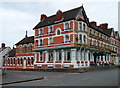
Grade II listed Royal Hotel, Avonmouth, Bristol
Located on the corner of Clayton Street (on the left) and Gloucester Road, near Avonmouth railway station. The hotel and the adjacent row of shops (numbers 7-26 Gloucester Road), all dating from c1870, were Grade II listed in March 1977.
Image: © Jaggery
Taken: 23 Jun 2012
0.03 miles