IMAGES TAKEN NEAR TO
Kings Weston Lane, BRISTOL, BS11 8AU
Introduction
This page details the photographs taken nearby to Kings Weston Lane, BS11 8AU by members of the Geograph project.
The Geograph project started in 2005 with the aim of publishing, organising and preserving representative images for every square kilometre of Great Britain, Ireland and the Isle of Man.

There are currently over 7.5m images from over14,400 individuals and you can help contribute to the project by visiting https://www.geograph.org.uk
Image Map
Images are licensed for reuse under creativecommons.org/licenses/by-sa/2.0
Notes
- Clicking on the map will re-center to the selected point.
- The higher the marker number, the further away the image location is from the centre of the postcode.
Image Listing (21 Images Found)
Images are licensed for reuse under creativecommons.org/licenses/by-sa/2.0
Image
Details
Distance
1
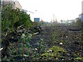
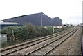
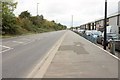
Disused railway trackbed, Avonmouth
The line of the industrial railway can be seen leading south away from the viewpoint at the level crossing in Smoke Lane. It isn't clear when the track was lifted but traces of it remain in the form of wooden sleepers in the vegetation at the left and stacked up a little further on.
Image: © Brian Robert Marshall
Taken: 25 Nov 2007
0.06 miles
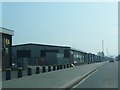
4
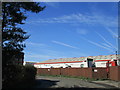
Industry, St Andrew's Road, Avonmouth
Industrial sites at the junction with Ironchurch Road
Image: © David Smith
Taken: 18 Oct 2017
0.12 miles
5
Ironchurch Road
Most of the premises in this area seem to be engaged in recycling of one form or another.
Image: © Jonathan Thacker
Taken: 19 Sep 2017
0.12 miles
6
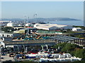
Down St Andrews Road
Looking southwesterly along the Avonmouth industrial complex and the many varieties of businesses here. Portishead lies on the headland in the distance.
Image: © Neil Owen
Taken: 14 Sep 2019
0.14 miles
8
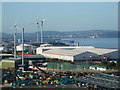
New energy in Avonmouth
The sprawling industrial complex that is Avonmouth has had many chimneys but these days there are more likely to be wind turbines on the skyline.
Image: © Neil Owen
Taken: 14 Sep 2019
0.16 miles
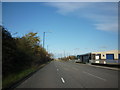
9
St Andrew's Road, Avonmouth
The A403 running beside the Severnside Trading Estate (right, Image]).
Image: © Derek Harper
Taken: 19 Oct 2016
0.16 miles
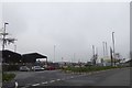
10
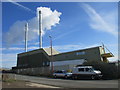
SRCL waste to energy plant
A clinical waste incinerator http://www.srcl.com/latest-news/avonmouth-waste-energy-plant-opens/
Image: © Jonathan Thacker
Taken: 19 Sep 2017
0.18 miles