IMAGES TAKEN NEAR TO
Berwick Court, BRISTOL, BS10 7SH
Introduction
This page details the photographs taken nearby to Berwick Court, BS10 7SH by members of the Geograph project.
The Geograph project started in 2005 with the aim of publishing, organising and preserving representative images for every square kilometre of Great Britain, Ireland and the Isle of Man.

There are currently over 7.5m images from over14,400 individuals and you can help contribute to the project by visiting https://www.geograph.org.uk
Image Map
Images are licensed for reuse under creativecommons.org/licenses/by-sa/2.0
Notes
- Clicking on the map will re-center to the selected point.
- The higher the marker number, the further away the image location is from the centre of the postcode.
Image Listing (13 Images Found)
Images are licensed for reuse under creativecommons.org/licenses/by-sa/2.0
Image
Details
Distance
3
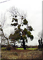
Tree by Old Elizabethan's RFC
Tree covered in mistletoe on the edge of the rugby pitch, by Severn Road.
Image: © Linda Bailey
Taken: 7 Feb 2006
0.13 miles

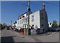
6
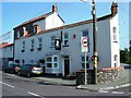
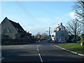
King William IV Public House Hallen
The pub is right opposite the Church - all spiritiual needs covered!
Image: © Damon Knight
Taken: 25 Aug 2007
0.17 miles
7
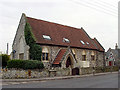
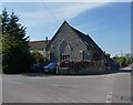
Church in Hallen
The church is at the cross-roads in Hallen.
Image: © Linda Bailey
Taken: 7 Feb 2006
0.18 miles