IMAGES TAKEN NEAR TO
Ison Hill, BRISTOL, BS10 7SG
Introduction
This page details the photographs taken nearby to Ison Hill, BS10 7SG by members of the Geograph project.
The Geograph project started in 2005 with the aim of publishing, organising and preserving representative images for every square kilometre of Great Britain, Ireland and the Isle of Man.

There are currently over 7.5m images from over14,400 individuals and you can help contribute to the project by visiting https://www.geograph.org.uk
Image Map
Images are licensed for reuse under creativecommons.org/licenses/by-sa/2.0
Notes
- Clicking on the map will re-center to the selected point.
- The higher the marker number, the further away the image location is from the centre of the postcode.
Image Listing (7 Images Found)
Images are licensed for reuse under creativecommons.org/licenses/by-sa/2.0
Image
Details
Distance
2
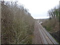
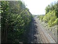
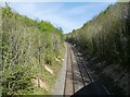
Hallen Halt railway station (site), Gloucestershire
Opened in 1910 by the Great Western Railway on the (then single) line from Filton Junction to Avonmouth Docks, this station closed in 1915, then reopened in 1917 until late 1918.
View west towards Chittening Platform and Avonmouth. The single platform was to the right of the track.
Image: © Nigel Thompson
Taken: 31 Mar 2018
0.04 miles