IMAGES TAKEN NEAR TO
Henbury Road, BRISTOL, BS10 7QS
Introduction
This page details the photographs taken nearby to Henbury Road, BS10 7QS by members of the Geograph project.
The Geograph project started in 2005 with the aim of publishing, organising and preserving representative images for every square kilometre of Great Britain, Ireland and the Isle of Man.

There are currently over 7.5m images from over14,400 individuals and you can help contribute to the project by visiting https://www.geograph.org.uk
Image Map
Images are licensed for reuse under creativecommons.org/licenses/by-sa/2.0
Notes
- Clicking on the map will re-center to the selected point.
- The higher the marker number, the further away the image location is from the centre of the postcode.
Image Listing (146 Images Found)
Images are licensed for reuse under creativecommons.org/licenses/by-sa/2.0
Image
Details
Distance
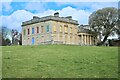
1
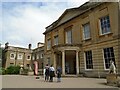
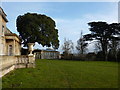
Blaise Castle House
Blaise Castle House was built in 1795 - 1799 by William Paty. It was extended in 1831 - 1832 by CR Cockerell. It is now a museum.
Image: © s
Taken: 8 Aug 2018
0.01 miles
2
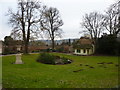
Blaise Castle Estate Museum, Bristol
This is a small but beautiful free museum with a wide range of historical domestic items such as toys, clothes, pictures, household equipment etc. well worth a visit.
Image: © Nigel Mykura
Taken: 6 Aug 2009
0.02 miles
3
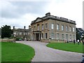
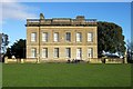
Blaise Castle House
A 19th century mansion which is now a museum of everyday objects from the past such as toys, model trains, kitchen equipment and Victorian toilets. The house was built in 1796-98 for John Harford, who was a wealthy Bristol merchant and banker. He was also responsible for building Blaise Hamlet, to house his servants and tenants.
Image: © Linda Bailey
Taken: 30 Oct 2004
0.02 miles
4
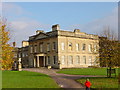
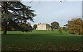
Blaise Castle House
Looking NE towards Blaise Castle House
Image: © Linda Bailey
Taken: 30 Oct 2004
0.02 miles
6
Thatched cottage
In the grounds of Blaise Castle Estate
Image: © Peter Barr
Taken: 6 Feb 2010
0.02 miles
7
Blaise Castle House Museum
Another view of the building shown at http://www.geograph.org.uk/search.php?i=46659278 . http://list.english-heritage.org.uk/resultsingle.aspx?uid=1279500&searchtype=mapsearch
Image: © Derek Harper
Taken: 19 Jan 2014
0.02 miles
8

Blaise Castle House Museum
Also shown at http://www.geograph.org.uk/search.php?i=46633656 . A description of the building is at http://list.english-heritage.org.uk/resultsingle.aspx?uid=1279500&searchtype=mapsearch . Behind the tree on the right is the Orangery http://list.english-heritage.org.uk/resultsingle.aspx?uid=1293345&searchtype=mapsearch and the church of St Mary http://list.english-heritage.org.uk/resultsingle.aspx?uid=1205113&searchtype=mapsearch .
Image: © Derek Harper
Taken: 19 Jan 2014
0.02 miles
9
Blaise Castle House
See http://www.geograph.org.uk/search.php?i=58857613 for closer views of the grade II* listed house http://www.historicengland.org.uk/listing/the-list/list-entry/1279500 .
Image: © Derek Harper
Taken: 25 Oct 2015
0.02 miles
10
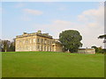
Blaise Castle Estate (9)
Mansion / museum
Image: © Anthony O'Neil
Taken: 16 Apr 2021
0.02 miles