IMAGES TAKEN NEAR TO
Meadowland Road, BRISTOL, BS10 7PP
Introduction
This page details the photographs taken nearby to Meadowland Road, BS10 7PP by members of the Geograph project.
The Geograph project started in 2005 with the aim of publishing, organising and preserving representative images for every square kilometre of Great Britain, Ireland and the Isle of Man.

There are currently over 7.5m images from over14,400 individuals and you can help contribute to the project by visiting https://www.geograph.org.uk
Image Map
Images are licensed for reuse under creativecommons.org/licenses/by-sa/2.0
Notes
- Clicking on the map will re-center to the selected point.
- The higher the marker number, the further away the image location is from the centre of the postcode.
Image Listing (7 Images Found)
Images are licensed for reuse under creativecommons.org/licenses/by-sa/2.0
Image
Details
Distance
1
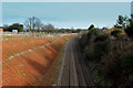
Railway Cutting along the Northern Edge of Henbury
As seen from a footbridge adopted by the Community Forest Path LDP - looking east.
Image: © Chris Heaton
Taken: 10 Feb 2016
0.06 miles
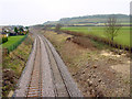
2
Crossing the Henbury Loop railway line
The hillslope below Haw Wood in the distance holds part of the extensive Hallen Fuel Storage Depot
Image: © Tim Heaton
Taken: 10 Feb 2016
0.14 miles
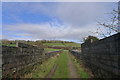
3
Railway track, from Station Road, Henbury
Taken from the bridge on Station Road (there isn't a station here now) looking west. Haw Wood is on the horizon.
Image: © Linda Bailey
Taken: 1 Feb 2006
0.15 miles
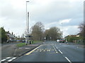
5
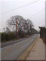
Station Road, Henbury
The rise in the road is the bridge over the railway line.
Image: © Linda Bailey
Taken: 1 Feb 2006
0.20 miles
6
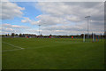
Bristol : The Lawns
Cribbs FC vs Willand Rovers at The Lawns.
Image: © Lewis Clarke
Taken: 6 Apr 2019
0.22 miles
7
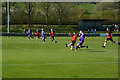
Bristol : The Lawns
Cribbs FC vs Willand Rovers at The Lawns.
Image: © Lewis Clarke
Taken: 6 Apr 2019
0.23 miles