IMAGES TAKEN NEAR TO
Strathearn Drive, BRISTOL, BS10 6TJ
Introduction
This page details the photographs taken nearby to Strathearn Drive, BS10 6TJ by members of the Geograph project.
The Geograph project started in 2005 with the aim of publishing, organising and preserving representative images for every square kilometre of Great Britain, Ireland and the Isle of Man.

There are currently over 7.5m images from over14,400 individuals and you can help contribute to the project by visiting https://www.geograph.org.uk
Image Map (Loading...)


Getting Data...Please wait
Leaflet Map data © OpenStreetMap
Images are licensed for reuse under creativecommons.org/licenses/by-sa/2.0
Notes
- Clicking on the map will re-center to the selected point.
- The higher the marker number, the further away the image location is from the centre of the postcode.
Image Listing (28 Images Found)
Images are licensed for reuse under creativecommons.org/licenses/by-sa/2.0
Image
Details
Distance
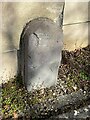
1
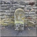
Old Boundary Marker
Municipal Boundary Marker against a stone garden wall on the southeast side of Charlton Road, opposite the junction with Robin Close. On the former boundary of City of Bristol and Westbury upon Trym parish, but now entirely in Bristol. Inscribed C B /1904.
Milestone Society National ID: GL_BSWEST02pb
Image: © S Kosciow
Taken: 21 May 2020
0.07 miles
2
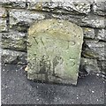
Old Boundary Marker
Parish Boundary Marker against a stone garden wall on the southeast side of Charlton Road, almost opposite the junction with Robin Close. On the former boundary of City of Bristol and Westbury upon Trym parish, but now entirely in Bristol. Inscribed W P / 1803.
Milestone Society National ID: GL_BSWEST03pb
Image: © S Kosciow
Taken: 21 May 2020
0.07 miles
3
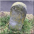
Old Boundary Marker
Municipal Boundary Marker on the grass verge on the southeast side of Charlton Road, almost opposite the junction with Royal Victoria Park. On the former boundary of City of Bristol and Westbury upon Trym parish, but now entirely in Bristol. Inscribed C B /1904.
Milestone Society National ID: GL_BSWEST01pb
Image: © S Kosciow
Taken: 21 May 2020
0.09 miles
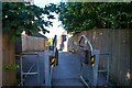
4
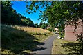
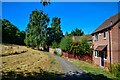
Bristol : Footpath
A footpath connecting homes.
Image: © Lewis Clarke
Taken: 10 Aug 2022
0.12 miles
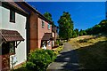
5
Bristol : Footpath
A footpath connecting homes.
Image: © Lewis Clarke
Taken: 10 Aug 2022
0.12 miles
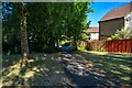
6
Bristol : Footpath
A footpath connecting homes.
Image: © Lewis Clarke
Taken: 10 Aug 2022
0.12 miles
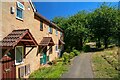
7
Bristol : Footpath
A footpath down to Pine Road.
Image: © Lewis Clarke
Taken: 10 Aug 2022
0.13 miles
8
Bristol : Footpath
A footpath connecting homes.
Image: © Lewis Clarke
Taken: 10 Aug 2022
0.14 miles
9
Old Boundary Marker on the entry drive to Royal Victoria Park
Parish Boundary Marker against the wall of Ruskin Cottage on the northwest side of the entry drive to Royal Victoria Park. Without an inscription it is difficult to determine the function of the stone. A boundary stone is marked on an OS map surveyed in 1879 so it may mark the boundary of Henbury and Westbury on Trym parishes. Now entirely in the City of Bristol.
Milestone Society National ID: GL_BRIS23pb
Image: © S Kosciow
Taken: 3 Apr 2022
0.15 miles
10
Bristol : Footpath
A footpath heading off to Thornfield Road.
Image: © Lewis Clarke
Taken: 10 Aug 2022
0.15 miles