IMAGES TAKEN NEAR TO
Knole Lane, BRISTOL, BS10 6RY
Introduction
This page details the photographs taken nearby to Knole Lane, BS10 6RY by members of the Geograph project.
The Geograph project started in 2005 with the aim of publishing, organising and preserving representative images for every square kilometre of Great Britain, Ireland and the Isle of Man.

There are currently over 7.5m images from over14,400 individuals and you can help contribute to the project by visiting https://www.geograph.org.uk
Image Map
Images are licensed for reuse under creativecommons.org/licenses/by-sa/2.0
Notes
- Clicking on the map will re-center to the selected point.
- The higher the marker number, the further away the image location is from the centre of the postcode.
Image Listing (35 Images Found)
Images are licensed for reuse under creativecommons.org/licenses/by-sa/2.0
Image
Details
Distance
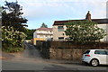
1

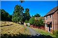
Bristol : Footpath
A footpath connecting homes.
Image: © Lewis Clarke
Taken: 10 Aug 2022
0.07 miles
2
Bristol : Footpath
A footpath connecting homes.
Image: © Lewis Clarke
Taken: 10 Aug 2022
0.08 miles
3
Bristol : Footpath
A footpath connecting homes.
Image: © Lewis Clarke
Taken: 10 Aug 2022
0.09 miles
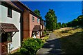
4
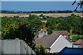
Bristol : Suburb Scenery
Looking out across some rooftops from Forest Drive.
Image: © Lewis Clarke
Taken: 10 Aug 2022
0.10 miles
5
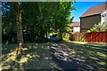
Bristol : Footpath
A footpath down to Pine Road.
Image: © Lewis Clarke
Taken: 10 Aug 2022
0.10 miles
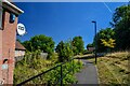
7
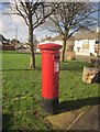
Postbox, Brentry
George VI postbox BS10 500 can be seen in Image
Image: © Derek Harper
Taken: 22 Feb 2014
0.12 miles
8
Green, Okebourne Road
Seen from St Joseph's Road. Gilslake Avenue is on this side of the green, Okebourne Road on the far side. Large rocks deter anyone from driving on to the green and protect the trees.
Image: © Derek Harper
Taken: 22 Feb 2014
0.12 miles
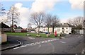
9
Bristol : Footpath
A footpath connecting homes.
Image: © Lewis Clarke
Taken: 10 Aug 2022
0.12 miles
10
Bourne End, Brentry
Okebourne Road curves past the pub on the left. I fear it has closed.
Image: © Derek Harper
Taken: 22 Feb 2014
0.13 miles