1
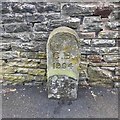
Old Boundary Marker
Municipal Boundary Marker against a stone garden wall on the southeast side of Charlton Road, opposite the junction with Robin Close. On the former boundary of City of Bristol and Westbury upon Trym parish, but now entirely in Bristol. Inscribed C B /1904.
Milestone Society National ID: GL_BSWEST02pb
Image: © S Kosciow
Taken: 21 May 2020
0.09 miles
2
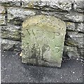
Old Boundary Marker
Parish Boundary Marker against a stone garden wall on the southeast side of Charlton Road, almost opposite the junction with Robin Close. On the former boundary of City of Bristol and Westbury upon Trym parish, but now entirely in Bristol. Inscribed W P / 1803.
Milestone Society National ID: GL_BSWEST03pb
Image: © S Kosciow
Taken: 21 May 2020
0.09 miles
3
Wigton Crescent, Southmead, Bristol
A row of houses on the north side of Wigton Crescent, viewed from near the corner of Lanercost Road.
Image: © Jaggery
Taken: 6 Nov 2010
0.12 miles
4
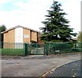
St Vincent de Paul, R.C. Church
Image: © John Lord
Taken: 24 Mar 2012
0.13 miles
5
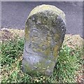
Old Boundary Marker
Municipal Boundary Marker on the grass verge on the southeast side of Charlton Road, almost opposite the junction with Royal Victoria Park. On the former boundary of City of Bristol and Westbury upon Trym parish, but now entirely in Bristol. Inscribed C B /1904.
Milestone Society National ID: GL_BSWEST01pb
Image: © S Kosciow
Taken: 21 May 2020
0.16 miles
6
Church of Jesus Christ of Latter Day Saints, Southmead, Bristol
Located on the corner of Lanercost Road and Keswick Walk, adjacent to the NE corner of Glencoyne Square.
Image: © Jaggery
Taken: 6 Nov 2010
0.16 miles
7
Mormon church, Southmead
Image: © Eirian Evans
Taken: 19 Apr 2017
0.17 miles
8
Dunmail Road, Southmead, Bristol
The view west along Dunmail Road from the corner of Ravenglass Crescent.
The triangular road sign in the distance is at the junction with Lanercost Road.
Image: © Jaggery
Taken: 6 Nov 2010
0.17 miles
9
Embleton Road, Southmead, Bristol
Viewed from near the NW edge of Glencoyne Square, looking in the direction of Little Mead Primary School. A children's playground is on the left.
Image: © Jaggery
Taken: 6 Nov 2010
0.18 miles
10
St Vincent de Paul Roman Catholic Church, Southmead, Bristol
Located at the NW corner of Glencoyne Square. Built in the mid 1950s, the church's distinguishing external feature is a tall campanile (bell tower) with a single bell, and a large cross atop the campanile.
Image: © Jaggery
Taken: 6 Nov 2010
0.19 miles


