IMAGES TAKEN NEAR TO
Wigton Crescent, BRISTOL, BS10 6DU
Introduction
This page details the photographs taken nearby to Wigton Crescent, BS10 6DU by members of the Geograph project.
The Geograph project started in 2005 with the aim of publishing, organising and preserving representative images for every square kilometre of Great Britain, Ireland and the Isle of Man.

There are currently over 7.5m images from over14,400 individuals and you can help contribute to the project by visiting https://www.geograph.org.uk
Image Map
Images are licensed for reuse under creativecommons.org/licenses/by-sa/2.0
Notes
- Clicking on the map will re-center to the selected point.
- The higher the marker number, the further away the image location is from the centre of the postcode.
Image Listing (39 Images Found)
Images are licensed for reuse under creativecommons.org/licenses/by-sa/2.0
Image
Details
Distance
2
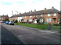
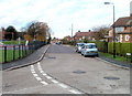
Wigton Crescent, Southmead, Bristol
A row of houses on the north side of Wigton Crescent, viewed from near the corner of Lanercost Road.
Image: © Jaggery
Taken: 6 Nov 2010
0.08 miles
3
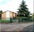
Church of Jesus Christ of Latter Day Saints, Southmead, Bristol
Located on the corner of Lanercost Road and Keswick Walk, adjacent to the NE corner of Glencoyne Square.
Image: © Jaggery
Taken: 6 Nov 2010
0.08 miles
4
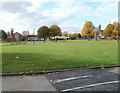
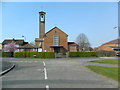
Glencoyne Square, Southmead, Bristol
The view from the east. There are two churches in view. On the left is St Stephens; http://www.geograph.org.uk/photo/2150533 on the right is St Vincent de Paul. http://www.geograph.org.uk/photo/2150508
Image: © Jaggery
Taken: 6 Nov 2010
0.10 miles
5
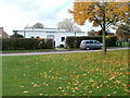
The White Hall, Glencoyne Square, Southmead, Bristol
Located on the west side of Glencoyne Square. The hall is used for St Stephens Community Work Project.
Image: © Jaggery
Taken: 6 Nov 2010
0.10 miles
6
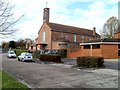
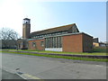
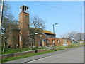
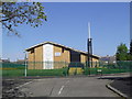
St Vincent de Paul Roman Catholic Church, Southmead, Bristol
Located at the NW corner of Glencoyne Square. Built in the mid 1950s, the church's distinguishing external feature is a tall campanile (bell tower) with a single bell, and a large cross atop the campanile.
Image: © Jaggery
Taken: 6 Nov 2010
0.10 miles
8
Embleton Road, Southmead, Bristol
Viewed from near the NW edge of Glencoyne Square, looking in the direction of Little Mead Primary School. A children's playground is on the left.
Image: © Jaggery
Taken: 6 Nov 2010
0.11 miles