IMAGES TAKEN NEAR TO
Pen Park Road, BRISTOL, BS10 5ST
Introduction
This page details the photographs taken nearby to Pen Park Road, BS10 5ST by members of the Geograph project.
The Geograph project started in 2005 with the aim of publishing, organising and preserving representative images for every square kilometre of Great Britain, Ireland and the Isle of Man.

There are currently over 7.5m images from over14,400 individuals and you can help contribute to the project by visiting https://www.geograph.org.uk
Image Map
Images are licensed for reuse under creativecommons.org/licenses/by-sa/2.0
Notes
- Clicking on the map will re-center to the selected point.
- The higher the marker number, the further away the image location is from the centre of the postcode.
Image Listing (57 Images Found)
Images are licensed for reuse under creativecommons.org/licenses/by-sa/2.0
Image
Details
Distance
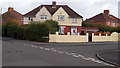
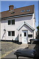
1
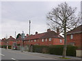
Houses on Pen Park Road
These red brick built houses on the northern skirts of Southmead were almost certainly built as social housing. Some of them are semi-detached and some are small terraces as here.
Image: © Nigel Mykura
Taken: 23 Feb 2013
0.06 miles
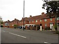
3
Lydney Road, Southmead, Bristol
Houses on the corner of Lydney Road, viewed across Pen Park Road.
Image: © Jaggery
Taken: 6 Nov 2010
0.07 miles
4
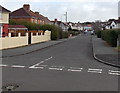
Felstead Road, Bristol
Viewed from Stanton Road looking along Felstead Road towards Knighton Road.
Image: © Jaggery
Taken: 30 Jan 2013
0.08 miles
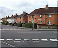
5
Corner of Stanton Road and Felstead Road, Bristol
Located in the far north of Bristol, near Filton in South Gloucestershire.
Image: © Jaggery
Taken: 30 Jan 2013
0.08 miles
6
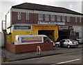
Garage and church, Southmead, Bristol
Viewed across Pen Park Road. Autotronic Motor Services at street level,
the Redeemed Christian Church of God (Christ Assembly Bristol) above.
Image: © Jaggery
Taken: 30 Jan 2013
0.09 miles
7
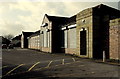
Bristol Centre for Music and the Arts
Located in former school buildings at the edge of the present-day Fonthill Primary School, accessed from Stanton Road.
Image: © Jaggery
Taken: 30 Jan 2013
0.10 miles

9
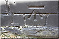
Benchmark on #1 Pen Park Road
Ordnance Survey cut mark benchmark described on the Bench Mark Database at http://www.bench-marks.org.uk/bm57117
Image: © Roger Templeman
Taken: 3 May 2014
0.11 miles
10
#1 Pen Park Road at Southmead Road junction
There is an OS benchmark Image on the side of the building above the narrow passage which runs along its right hand side
Image: © Roger Templeman
Taken: 3 May 2014
0.11 miles