IMAGES TAKEN NEAR TO
Knighton Road, BRISTOL, BS10 5SF
Introduction
This page details the photographs taken nearby to Knighton Road, BS10 5SF by members of the Geograph project.
The Geograph project started in 2005 with the aim of publishing, organising and preserving representative images for every square kilometre of Great Britain, Ireland and the Isle of Man.

There are currently over 7.5m images from over14,400 individuals and you can help contribute to the project by visiting https://www.geograph.org.uk
Image Map (Loading...)


Getting Data...Please wait
Leaflet Map data © OpenStreetMap
Images are licensed for reuse under creativecommons.org/licenses/by-sa/2.0
Notes
- Clicking on the map will re-center to the selected point.
- The higher the marker number, the further away the image location is from the centre of the postcode.
Image Listing (49 Images Found)
Images are licensed for reuse under creativecommons.org/licenses/by-sa/2.0
Image
Details
Distance
1
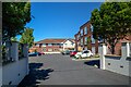
Bristol : Dearbourne Manor
Looking towards the house off Southmead Road.
Image: © Lewis Clarke
Taken: 10 Aug 2022
0.04 miles
2
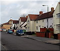
Stanton Road, Bristol
The arrow on the sign on the lamppost points left towards Bristol Centre for Music and the Arts.
Image: © Jaggery
Taken: 30 Jan 2013
0.07 miles
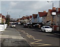
3
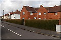
Semis in different streets, Bristol
The semi-detached house on the left is 59 Stanton Road. Next door on the right is 1 Home Close.
Image: © Jaggery
Taken: 30 Jan 2013
0.07 miles
4
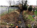
Stream misused as a rubbish dump, Stanton Road, Bristol
Viewed from the NE end of the road. The fence is at the perimeter of the BAWA site. http://www.geograph.org.uk/photo/2150171
Image: © Jaggery
Taken: 30 Jan 2013
0.08 miles
5
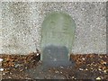
Old Boundary Marker by Kenmore Grove, Bristol
Parish Boundary Marker by the UC road, in parish of Bristol (City of Bristol District), Kenmore Grove, next to the junction with the B4056, Southmead Road, against garden wall.
Inscription reads:-
C B
----
1904
Surveyed
Milestone Society National ID: GL_BSFIL01pb
Image: © Milestone Society
Taken: Unknown
0.08 miles
6
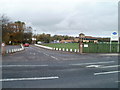
Entrance to BAWA, Filton
Viewed across Southmead Road. BAWA http://www.geograph.org.uk/photo/358854 was founded in 1942 as the Bristol Aeroplane Company Welfare Association to provide a centralised service for sickness pay and sports and social activities for company employees. The current acronym BAWA dates from 1973 when the Association was renamed the Bristol Aerospace Welfare Association.
Image: © Jaggery
Taken: 6 Nov 2010
0.08 miles
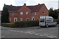
7

BAWA Sports and Social Club - Filton
Built in the 1990's on the site of the previous one.
Image: © Linda Bailey
Taken: 26 Jan 2006
0.08 miles
8

Filton : Bawa Leisure
A leisure area and sports fields.
Image: © Lewis Clarke
Taken: 10 Aug 2022
0.08 miles
9
Corner of Home Close and Stanton Road, Bristol
Located in the far north of Bristol, near Filton in South Gloucestershire.
Image: © Jaggery
Taken: 30 Jan 2013
0.08 miles
10
Eastern end of Stanton Road, Bristol
Viewed from near the corner of Home Close. Stanton Road ends at the edge of the BAWA site. http://www.geograph.org.uk/photo/2150171
Image: © Jaggery
Taken: 30 Jan 2013
0.09 miles