1
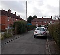
Royston Walk, Bristol
A 70 metre long cul-de-sac on the west side of Pen Park Road.
Image: © Jaggery
Taken: 30 Jan 2013
0.11 miles
2
Lydney Road, Southmead, Bristol
Houses on the corner of Lydney Road, viewed across Pen Park Road.
Image: © Jaggery
Taken: 6 Nov 2010
0.12 miles
3
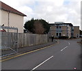
20 zone in Eastleigh Road, BS10, Bristol
A 20 mph maximum speed limit is in force near a school. Viewed from the corner of Greystoke Avenue.
Image: © Jaggery
Taken: 30 Jan 2013
0.13 miles
4
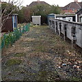
Western Power Distribution electricity substation, Greystoke Avenue, Bristol
Viewed over the locked gate of a compound between two Greystoke Avenue houses. The substation is the grey box located 35 metres from the gate. The site identifier is GREYSTOKE AVE PEN PARK.
Image: © Jaggery
Taken: 30 Jan 2013
0.14 miles
5
Houses on Pen Park Road
These red brick built houses on the northern skirts of Southmead were almost certainly built as social housing. Some of them are semi-detached and some are small terraces as here.
Image: © Nigel Mykura
Taken: 23 Feb 2013
0.15 miles
6
Shops at a busy crossroads, Southmead, Bristol
Viewed across Southmead Road. The shops face Lidl http://www.geograph.org.uk/photo/2150279 adjacent to a mini-roundabout.
The premises include three food establishments (a Thai restaurant & takeaway, a Polish delicatessen, and tandoori Indian takeaway). In the middle are Redeemed Christian Church of God premises.
Image: © Jaggery
Taken: 6 Nov 2010
0.15 miles
7
Pen Park Road
Image: © Roger Cornfoot
Taken: 7 Oct 2020
0.15 miles
8
Glencoyne Square - Southmead
A peaceful day at the local summer fair in one of Bristol's less privileged suburbs.
Image: © John Phillips
Taken: 28 Jun 2003
0.16 miles
9
Southmead House, Southmead, Bristol
The Bristol City Council site is set back from the south side of Greystoke Avenue.
Southmead House is a customer service point, and provides health are adult social care services.
Image: © Jaggery
Taken: 30 Jan 2013
0.17 miles
10
Garage and church, Southmead, Bristol
Viewed across Pen Park Road. Autotronic Motor Services at street level,
the Redeemed Christian Church of God (Christ Assembly Bristol) above.
Image: © Jaggery
Taken: 30 Jan 2013
0.17 miles


