IMAGES TAKEN NEAR TO
Coleford Road, BRISTOL, BS10 5JH
Introduction
This page details the photographs taken nearby to Coleford Road, BS10 5JH by members of the Geograph project.
The Geograph project started in 2005 with the aim of publishing, organising and preserving representative images for every square kilometre of Great Britain, Ireland and the Isle of Man.

There are currently over 7.5m images from over14,400 individuals and you can help contribute to the project by visiting https://www.geograph.org.uk
Image Map (Loading...)


Getting Data...Please wait
Leaflet Map data © OpenStreetMap
Images are licensed for reuse under creativecommons.org/licenses/by-sa/2.0
Notes
- Clicking on the map will re-center to the selected point.
- The higher the marker number, the further away the image location is from the centre of the postcode.
Image Listing (45 Images Found)
Images are licensed for reuse under creativecommons.org/licenses/by-sa/2.0
Image
Details
Distance
1
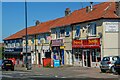
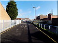
Bristol : Doncaster Road
Looking along Doncaster Road.
Image: © Lewis Clarke
Taken: 10 Aug 2022
0.05 miles
2
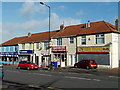
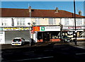
Shops at the SE end of Doncaster Road, Bristol
Viewed from near the corner of Southmead Road. Bristol Angling Centre http://www.geograph.org.uk/photo/3314798 is on the left.
Image: © Jaggery
Taken: 30 Jan 2013
0.07 miles
3
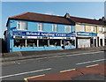
Bristol Angling Centre
Located at 12-16 Doncaster Road, Southmead, Bristol.
Image: © Jaggery
Taken: 30 Jan 2013
0.07 miles
4
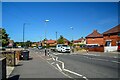
Bristol : Doncaster Road
Looking along Doncaster Road with shops including Oriental Sunrise, and Bargains Off Licence.
Image: © Lewis Clarke
Taken: 10 Aug 2022
0.08 miles
5
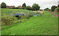
Lane from allotments to Doncaster Road, Southmead, Bristol
Viewed from the edge of these http://www.geograph.org.uk/photo/3314803 allotments.
Image: © Jaggery
Taken: 30 Jan 2013
0.08 miles
6
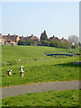
Southmead Bridge
This bridge was built by Southmead Trymside Environment Project (STEP), a community based initiative. The River Trym flows on through Westbury on Trym to join the River Avon at Sea Mills.
Image: © Linda Bailey
Taken: 2 Apr 2007
0.09 miles
7
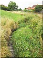
River Trym
A tiny stream here, less than 400 metres from its mapped source, seen looking upstream from Image
Image: © Derek Harper
Taken: 4 Aug 2013
0.10 miles
8
Trymside Bridge, Trymside Open Space
Image: © Derek Harper
Taken: 4 Aug 2013
0.11 miles
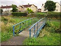
9
Trymside Bridge, Trymside Open Space
An unmapped bridge, also shown in Image, across the infant River Trym, carrying a path that links a cyclepath (right) with footpath BCC/43/10, which is mapped as continuing on the other side of the stream, but rather gives the impression of crossing it here. Southmead lies ahead, as the lettering on the bridge suggests.
Image: © Derek Harper
Taken: 4 Aug 2013
0.11 miles
10
African Textile Boutique, Bristol
The Southmead Road shop is part of this http://www.geograph.org.uk/photo/3314773 long row of shops.
Image: © Jaggery
Taken: 30 Jan 2013
0.11 miles