IMAGES TAKEN NEAR TO
Kendon Drive, BRISTOL, BS10 5BP
Introduction
This page details the photographs taken nearby to Kendon Drive, BS10 5BP by members of the Geograph project.
The Geograph project started in 2005 with the aim of publishing, organising and preserving representative images for every square kilometre of Great Britain, Ireland and the Isle of Man.

There are currently over 7.5m images from over14,400 individuals and you can help contribute to the project by visiting https://www.geograph.org.uk
Image Map (Loading...)


Getting Data...Please wait
Leaflet Map data © OpenStreetMap
Images are licensed for reuse under creativecommons.org/licenses/by-sa/2.0
Notes
- Clicking on the map will re-center to the selected point.
- The higher the marker number, the further away the image location is from the centre of the postcode.
Image Listing (21 Images Found)
Images are licensed for reuse under creativecommons.org/licenses/by-sa/2.0
Image
Details
Distance
1
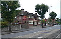
The Beehive
Public house on Wellington Hill West.
Image: © Eirian Evans
Taken: 30 Sep 2010
0.08 miles
3
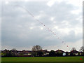
Kite Flying on Horfield C of E's playing field
The playing field of Horfield C of E, and on it a long string of kites, each with a message on the tail.
The houses at the end of the grass are on Maskelyne Avenue Image
Image: © Linda Bailey
Taken: 28 Apr 2006
0.09 miles
4
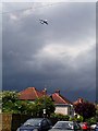
A380 Airbus over Cherrington Road
This was the first time the A380 Airbus had come to Bristol where parts of the wings and engine had been made at Airbus and Rolls Royce respectively. It did 3 circuits over to the Clifton Suspension Bridge (to pay a tribute to Brunel) and back up to the Filton Airfield where the staff were all out to watch. The plane then went on to Heathrow.
As the wings are 262 feet long, it is too large to land at either of the airports in Bristol. It was quiet even though it was flying quite low.
Image: © Linda Bailey
Taken: 18 May 2006
0.10 miles
5
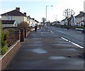
Wellington Hill West, Bristol
Looking east along Wellington Hill West from near the corner of Waterdale Gardens. http://www.geograph.org.uk/photo/3321941
Image: © Jaggery
Taken: 30 Jan 2013
0.10 miles
6
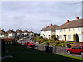
Looking along Maskelyne Avenue, Manor Farm
On the Manor Farm Estate, looking west along Maskelyne Avenue. These houses were built in the 1950's.
Image: © Linda Bailey
Taken: 28 Mar 2006
0.11 miles
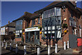
8
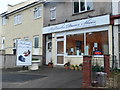
Get your dancing shoes on!
Holbrooks Dance Shoes shop on Wellington Hill West.
Image: © Eirian Evans
Taken: 30 Sep 2010
0.17 miles
10
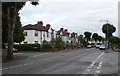
Waterdale Gardens, Bristol
A cul-de-sac on the north side of Wellington Hill West.
Image: © Jaggery
Taken: 30 Jan 2013
0.20 miles