IMAGES TAKEN NEAR TO
Rodbourne Road, BRISTOL, BS10 5AP
Introduction
This page details the photographs taken nearby to Rodbourne Road, BS10 5AP by members of the Geograph project.
The Geograph project started in 2005 with the aim of publishing, organising and preserving representative images for every square kilometre of Great Britain, Ireland and the Isle of Man.

There are currently over 7.5m images from over14,400 individuals and you can help contribute to the project by visiting https://www.geograph.org.uk
Image Map
Images are licensed for reuse under creativecommons.org/licenses/by-sa/2.0
Notes
- Clicking on the map will re-center to the selected point.
- The higher the marker number, the further away the image location is from the centre of the postcode.
Image Listing (93 Images Found)
Images are licensed for reuse under creativecommons.org/licenses/by-sa/2.0
Image
Details
Distance
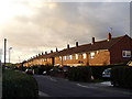
1
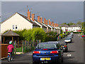
Looking along Rodbourne Road, Manor Farm
Looking north-east along Rodbourne Road. From where the red car on the edge of the photo is looking into the next square Image
Image: © Linda Bailey
Taken: 18 May 2006
0.02 miles
2
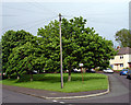
Looking up Francombe Grove, Manor Farm
This green island separates Rodbourne Road from Francombe Grove.
No Ball Games - on the sign.
Image: © Linda Bailey
Taken: 18 May 2006
0.09 miles
3
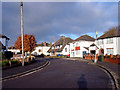
Weston Crescent, Horfield
Weston Crescent changes into Weston Road about this point. The common is behind me.
Image: © Linda Bailey
Taken: 1 Apr 2006
0.09 miles
4
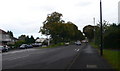
Kellaway Avenue
Looking down Kellaway Avenue, a tree-lined avenue in Horfield.
Image: © Eirian Evans
Taken: 30 Sep 2010
0.09 miles
5
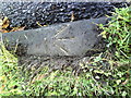
Benchmark on kerbstone of Kellaway Avenue
Ordnance Survey 1956 rivet benchmark which is described on the Bench Mark Database at http://www.bench-marks.org.uk/bm27966.
Image: © Roger Templeman
Taken: 14 Aug 2010
0.11 miles
6
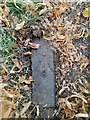
Ordnance Survey Rivet
This OS rivet can be found on a kerb stone NW side of Kellaway Avenue. It marks a point 83.451m above mean sea level.
Image: © Adrian Dust
Taken: 28 Jul 2022
0.11 miles
7
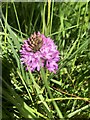
Pyramidal Orchid
Found in a grassy patch off Kellaway Avenue
Image: © Eirian Evans
Taken: 10 Jun 2022
0.11 miles
8
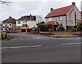
Abbots Way, Bristol
Houses at the eastern end of Abbots Way, viewed across Kellaway Avenue.
Image: © Jaggery
Taken: 30 Jan 2013
0.12 miles
9
Tilling Road
A narrow road, but well used as one of the back routes into Southmead Hospital.
Image: © Linda Bailey
Taken: 2 Oct 2006
0.12 miles
10
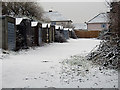
Garages in the snow
These garages are just off Bell Lane and last month have been fenced off to reduce vandalism I presume. The houses shown, are on Bishopthorpe Road.
Image: © Linda Bailey
Taken: 8 Feb 2007
0.13 miles