IMAGES TAKEN NEAR TO
Harnetts Close, Church Road, SWANLEY, BR8 8JZ
Introduction
This page details the photographs taken nearby to Harnetts Close, Church Road, BR8 8JZ by members of the Geograph project.
The Geograph project started in 2005 with the aim of publishing, organising and preserving representative images for every square kilometre of Great Britain, Ireland and the Isle of Man.

There are currently over 7.5m images from over14,400 individuals and you can help contribute to the project by visiting https://www.geograph.org.uk
Image Map (Loading...)


Getting Data...Please wait
Leaflet Map data © OpenStreetMap
Images are licensed for reuse under creativecommons.org/licenses/by-sa/2.0
Notes
- Clicking on the map will re-center to the selected point.
- The higher the marker number, the further away the image location is from the centre of the postcode.
Image Listing (91 Images Found)
Images are licensed for reuse under creativecommons.org/licenses/by-sa/2.0
Image
Details
Distance
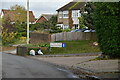
3
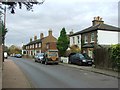
Entrance to Tudor Court off Old Chapel Road
Image: © Nick Smith
Taken: 27 Sep 2008
0.09 miles
4
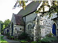
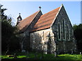
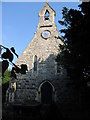
The east end of All Souls' church, Crockenhill
Image: © Nick Smith
Taken: 27 Sep 2008
0.09 miles
6
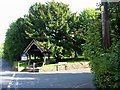
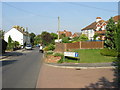
Lych gate to All Souls' church on Church Road
Image: © Nick Smith
Taken: 27 Sep 2008
0.09 miles
8
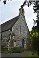
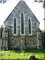
Church of All Souls
Grade II listed. https://historicengland.org.uk/listing/the-list/list-entry/1391291
Image: © N Chadwick
Taken: 6 Nov 2019
0.10 miles
10
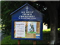
Notice board for All Souls' church, Crockenhill
Image: © Nick Smith
Taken: 27 Sep 2008
0.10 miles