IMAGES TAKEN NEAR TO
Alder Way, SWANLEY, BR8 7TA
Introduction
This page details the photographs taken nearby to Alder Way, BR8 7TA by members of the Geograph project.
The Geograph project started in 2005 with the aim of publishing, organising and preserving representative images for every square kilometre of Great Britain, Ireland and the Isle of Man.

There are currently over 7.5m images from over14,400 individuals and you can help contribute to the project by visiting https://www.geograph.org.uk
Image Map (Loading...)


Getting Data...Please wait
Leaflet Map data © OpenStreetMap
Images are licensed for reuse under creativecommons.org/licenses/by-sa/2.0
Notes
- Clicking on the map will re-center to the selected point.
- The higher the marker number, the further away the image location is from the centre of the postcode.
Image Listing (35 Images Found)
Images are licensed for reuse under creativecommons.org/licenses/by-sa/2.0
Image
Details
Distance
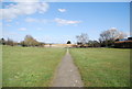
5
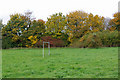
Forlorn goalposts
Showing little sign of recent use, these are in the field next to Swanley Park and accessible from it. There is only this one undersized set.
Image: © Robin Webster
Taken: 29 Oct 2010
0.09 miles
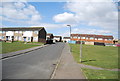
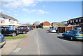
7
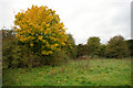
Autumn, Swanley
In a rougher part of Swanley Park.
Image: © Robin Webster
Taken: 29 Oct 2010
0.11 miles
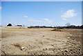
10
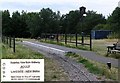
New Barn Halt
on the Swanley New Barn Railway http://www.snbr.20m.com/ in Swanley Park. This 7¼ inch gauge railway has over one kilometre of track and runs regularly.
Image: © Roger W Haworth
Taken: 2 Aug 2006
0.14 miles