IMAGES TAKEN NEAR TO
Northview, SWANLEY, BR8 7FR
Introduction
This page details the photographs taken nearby to Northview, BR8 7FR by members of the Geograph project.
The Geograph project started in 2005 with the aim of publishing, organising and preserving representative images for every square kilometre of Great Britain, Ireland and the Isle of Man.

There are currently over 7.5m images from over14,400 individuals and you can help contribute to the project by visiting https://www.geograph.org.uk
Image Map
Images are licensed for reuse under creativecommons.org/licenses/by-sa/2.0
Notes
- Clicking on the map will re-center to the selected point.
- The higher the marker number, the further away the image location is from the centre of the postcode.
Image Listing (12 Images Found)
Images are licensed for reuse under creativecommons.org/licenses/by-sa/2.0
Image
Details
Distance
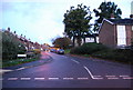
1
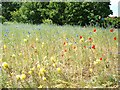
Swanley Park Wildflower Environment Area
Swanley Park, at The Birches showing Wildflower area in the Environment Area. May 29th 2011.
Image: © Dicky
Taken: 26 May 2011
0.06 miles
3
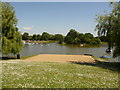
Swanley: looking across Swanley Park lake
Another view of Image, with a small island visible right of centre.
Image: © Chris Downer
Taken: 30 May 2009
0.19 miles
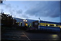
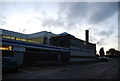
4
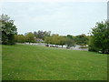
White Oaks Leisure Centre, Swanley
Website: http://www.sencio.org.uk/whiteoak.asp
Image: © N Chadwick
Taken: 30 Oct 2010
0.21 miles
6
White Oaks Leisure Centre
Website: http://www.sencio.org.uk/whiteoak.asp
Image: © N Chadwick
Taken: 30 Oct 2010
0.22 miles
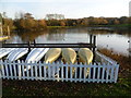
7
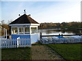
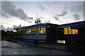
The lake in Swanley Park
Swanley Park used to be known as New Barn Park. Previous to that it was New Barn Farm until various fields and orchards were bought by the Town Council to protect the Green Belt between Hextable and Swanley. The lake at the eastern end of the park has a cafe, although in winter it is fairly quiet with the canoes laid up ready for the better weather. The hut is used for hiring out the canoes.
Image: © Marathon
Taken: 13 Jan 2012
0.22 miles
9
The lake in winter at Swanley Park
Swanley Park used to be known as New Barn Park. Previous to that it was New Barn Farm until various fields and orchards were bought by the Town Council to protect the Green Belt between Hextable and Swanley. The lake at the eastern end of the park has a cafe, although in winter it is fairly quiet with the boats laid up ready for the better weather.
Image: © Marathon
Taken: 13 Jan 2012
0.23 miles
10
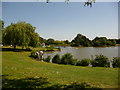
Swanley: Swanley Park lake
A picturesque lake towards the eastern side of Swanley Park. Out of picture to the left are children's playthings and a café/refreshment building, all making this a very popular spot on a hot, sunny Saturday afternoon during half term.
Image: © Chris Downer
Taken: 30 May 2009
0.23 miles