IMAGES TAKEN NEAR TO
Rowhill Road, SWANLEY, BR8 7FP
Introduction
This page details the photographs taken nearby to Rowhill Road, BR8 7FP by members of the Geograph project.
The Geograph project started in 2005 with the aim of publishing, organising and preserving representative images for every square kilometre of Great Britain, Ireland and the Isle of Man.

There are currently over 7.5m images from over14,400 individuals and you can help contribute to the project by visiting https://www.geograph.org.uk
Image Map
Images are licensed for reuse under creativecommons.org/licenses/by-sa/2.0
Notes
- Clicking on the map will re-center to the selected point.
- The higher the marker number, the further away the image location is from the centre of the postcode.
Image Listing (29 Images Found)
Images are licensed for reuse under creativecommons.org/licenses/by-sa/2.0
Image
Details
Distance
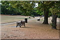
2
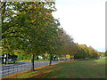
Trees beside Top Dartford Road
Row of Alder trees on the boundary of Hextable Recreational Ground.
The grass has been cut hence the lines of cut leaves.
In the background is the junction with Rowhill Road.
Image: © David Anstiss
Taken: 30 Oct 2012
0.11 miles
3
Houses by the top of the green, Hextable
Image: © David Martin
Taken: 21 Jul 2018
0.13 miles
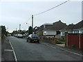
5
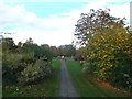
Path in Hextable Recreational Ground
This path leads up from Lower Road, through the large triangular recreational ground towards the play area near Home Hill (road).
Image: © David Anstiss
Taken: 30 Oct 2012
0.13 miles
6
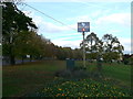
Hextable Village Sign
At the corner of the large recreational ground, beside Top Dartford Road (on the left).
Image: © David Anstiss
Taken: 30 Oct 2012
0.13 miles
7
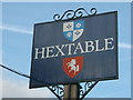
Hextable Village Sign (close-up)
Shows the Coat of Arms for the village.
Also shows 'Invicta' the prancing horse symbol of Kent.
See Image for positioning.
Image: © David Anstiss
Taken: 30 Oct 2012
0.14 miles
9
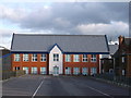
New Building, Furness School
This purple building is a new building in the complex of buildings of Furness School on Rowhill Road.
Image: © David Anstiss
Taken: 30 Oct 2012
0.14 miles