IMAGES TAKEN NEAR TO
A20, SWANLEY, BR8 7FL
Introduction
This page details the photographs taken nearby to A20, BR8 7FL by members of the Geograph project.
The Geograph project started in 2005 with the aim of publishing, organising and preserving representative images for every square kilometre of Great Britain, Ireland and the Isle of Man.

There are currently over 7.5m images from over14,400 individuals and you can help contribute to the project by visiting https://www.geograph.org.uk
Image Map
Images are licensed for reuse under creativecommons.org/licenses/by-sa/2.0
Notes
- Clicking on the map will re-center to the selected point.
- The higher the marker number, the further away the image location is from the centre of the postcode.
Image Listing (26 Images Found)
Images are licensed for reuse under creativecommons.org/licenses/by-sa/2.0
Image
Details
Distance
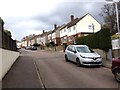
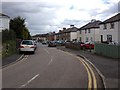
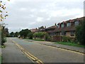
2
Swanley Lane, Swanley
The main road into town from the north.
Image: © David Howard
Taken: 25 Nov 2012
0.13 miles
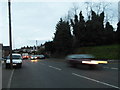
6
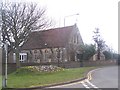
Swanley Catholic Church
On bend on B2173 Bartholomew Way.
Image: © David Anstiss
Taken: 3 Mar 2009
0.17 miles