IMAGES TAKEN NEAR TO
Norsted Lane, ORPINGTON, BR6 7PE
Introduction
This page details the photographs taken nearby to Norsted Lane, BR6 7PE by members of the Geograph project.
The Geograph project started in 2005 with the aim of publishing, organising and preserving representative images for every square kilometre of Great Britain, Ireland and the Isle of Man.

There are currently over 7.5m images from over14,400 individuals and you can help contribute to the project by visiting https://www.geograph.org.uk
Image Map
Images are licensed for reuse under creativecommons.org/licenses/by-sa/2.0
Notes
- Clicking on the map will re-center to the selected point.
- The higher the marker number, the further away the image location is from the centre of the postcode.
Image Listing (64 Images Found)
Images are licensed for reuse under creativecommons.org/licenses/by-sa/2.0
Image
Details
Distance
2
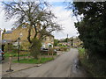
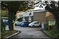
Norsted Lane, Pratts Bottom
Norstead Lane in the village of Pratts Bottom, on the outer fringe of south east London.
Image: © Malc McDonald
Taken: 9 Mar 2019
0.02 miles
3
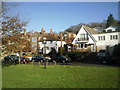
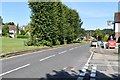
Green and village sign at Pratts Bottom
The village sign on the green in Pratts Bottom, photographed on a lovely clear winter's day.
Image: © Marathon
Taken: 9 Jan 2011
0.03 miles
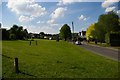
7
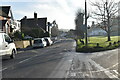
On the green at Pratts Bottom
Seen on a beautiful clear winter's day, the attractive green has some fine trees, as well as a village sign and a nearby pub and village hall.
Image: © Marathon
Taken: 9 Jan 2011
0.04 miles
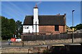
8
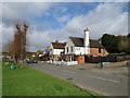
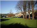
Bull's Head pub, Pratts Bottom
The Bull's Head pub looking out over the village green at Pratts Bottom, on the outer fringe of South East London.
Image: © Malc McDonald
Taken: 9 Mar 2019
0.04 miles
9
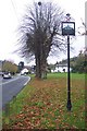
Pratt's Bottom Village Sign
On Rushmore Hill, on the village green. Close to the village pub and church.
The Village sign was to commemorate the Millennium and was organised by the
Pratts Bottom Residents Association. The sign was made by a resident of the
village. The house is the Tollhouse that was on the corner of Rushmore Hill and
Sevenoaks Road by the roundabout. Also shown are the heraldic arms of the
Diocese of Rochester and the Kentish Invicta. (Thanks to Gwyneth Hudson for info on the sign)
Image: © David Anstiss
Taken: 8 Nov 2009
0.04 miles