IMAGES TAKEN NEAR TO
Rushmore Hill, ORPINGTON, BR6 7NN
Introduction
This page details the photographs taken nearby to Rushmore Hill, BR6 7NN by members of the Geograph project.
The Geograph project started in 2005 with the aim of publishing, organising and preserving representative images for every square kilometre of Great Britain, Ireland and the Isle of Man.

There are currently over 7.5m images from over14,400 individuals and you can help contribute to the project by visiting https://www.geograph.org.uk
Image Map (Loading...)


Getting Data...Please wait
Leaflet Map data © OpenStreetMap
Images are licensed for reuse under creativecommons.org/licenses/by-sa/2.0
Notes
- Clicking on the map will re-center to the selected point.
- The higher the marker number, the further away the image location is from the centre of the postcode.
Image Listing (65 Images Found)
Images are licensed for reuse under creativecommons.org/licenses/by-sa/2.0
Image
Details
Distance
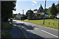
6
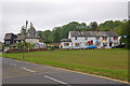
Pratt's Bottom Common
The bunting is in place for the Pratt's Bottom Fete, due to take place the following day.
Image: © Ian Capper
Taken: 16 May 2008
0.01 miles
8
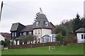
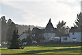
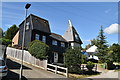
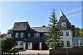
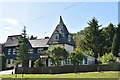
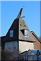
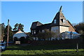
The Oast House, Pratt's Bottom
On Rushmore Hill, beside the village green.
Image: © David Anstiss
Taken: 8 Nov 2009
0.02 miles