IMAGES TAKEN NEAR TO
Valley Road, NEWHAVEN, BN9 9XE
Introduction
This page details the photographs taken nearby to Valley Road, BN9 9XE by members of the Geograph project.
The Geograph project started in 2005 with the aim of publishing, organising and preserving representative images for every square kilometre of Great Britain, Ireland and the Isle of Man.

There are currently over 7.5m images from over14,400 individuals and you can help contribute to the project by visiting https://www.geograph.org.uk
Image Map
Images are licensed for reuse under creativecommons.org/licenses/by-sa/2.0
Notes
- Clicking on the map will re-center to the selected point.
- The higher the marker number, the further away the image location is from the centre of the postcode.
Image Listing (15 Images Found)
Images are licensed for reuse under creativecommons.org/licenses/by-sa/2.0
Image
Details
Distance
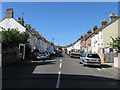
1
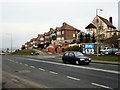
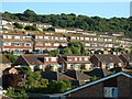
Houses on the Brighton Road
At the western end of Newhaven
Image: © Paul Gillett
Taken: 17 Mar 2010
0.13 miles
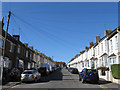
2
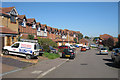
The Fairway
Terraced housing to the West of Newhaven.
Image: © Oast House Archive
Taken: 10 Oct 2010
0.18 miles
4
Evelyn Avenue
Built in the first decade or so of the 20th century and runs between Lewes Road and Murray Avenue. For many years it was a rat run for drivers who wished to avoid the ring road until the entrance via Murray Avenue on Brighton Road was closed.
Image: © Simon Carey
Taken: 31 Aug 2012
0.21 miles
5
Lawes Avenue
Built in the 1890s and connecting Lewes Road to Murray Avenue.
Image: © Simon Carey
Taken: 31 Aug 2012
0.21 miles
6
Willow Walk
Part of the Valley estate that was built during the 1960s. It is a cul de sac leading off Lee Way at the eastern end and linked to Lewes Road by way of a footpath.
Image: © Simon Carey
Taken: 31 Aug 2012
0.22 miles
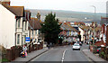
7
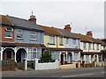
Terraced houses, Brighton Road, Newhaven
Image: © nick macneill
Taken: 4 Aug 2012
0.23 miles
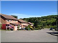
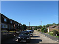
8
Modern Housing Estate at Newhaven
Modern Housing Estate North West Of Newhaven town Centre
Image: © Terry Jones
Taken: 13 Jun 2005
0.23 miles
9
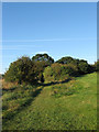
Hoathdown Avenue
The name of the footpath that links The Fairway to Lewes Road that was given sometime in the 1930s when it was planned to construct a road and houses but never materialised due to the war and tougher planning laws after. There also two footpaths here, one goes into the trees the other runs around outside next to the golf course.
Image: © Simon Carey
Taken: 31 Aug 2012
0.23 miles